

Admin Layers
- Save My Map
Road Conditions
Cameras & dms, construction.
- Transit/Rest Areas
- User Settings
- Show More Options...
- Follow Us on Twitter
- Download Our Mobile App
- General Help
Please select, from the options below, the layers that you would like to see on the map.
Please select, from the options below, the events that you would like to see on the map.
Legend Key:
Please select, from the options below, the cameras and DMSs that you would like to see on the map.

Please select, from the options below, the region you would like to zoom to.
- Albuquerque Area
- Albuquerque Metro
- Espanola/Los Alamos
- I-10 Corridor
- Northwest Region
- Southwest Region
- Southeast Region
- Northeast Region
- Central Region
- Northern Mountains
Please select, from the options below, the items that you would like to see on the map.

Construction Projects
Please select the project you are interested in from the list below.
For traffic conditions, select the option below.

Relevant Links
Please select the links you are interested in from the list below.
For rest areas, select the option below.

Transit & Trucking
Please select the resource you are interested in from the list below.

- All NM roads
- All NM interstates
- Northwest NM
- Southwest NM
- Southeast NM
- Northeast NM
- Northern Mountain roads
- Albuquerque roads
- Santa Fe roads
- Las Cruces roads
- I 25 between Albuquerque and Santa Fe
Find the Fastest Route
Enter your starting address and your destination to get the fastest route.

General Information:
NMDOT General Office: 1120 Cerrillos Road, Santa Fe, NM, 87504-1149 | Telephone: (505)795-1401 | Road Advisory Hotline: 511 or (800)432-4269
NMOADS.com has been developed & is hosted & maintained by Real Time Solutions .
- About the Project
Account Information:
Account deleted successfully..
Your account has been successfully deleted. You can now close this window.
Route Subscriptions:
Route subscriptions wizard:, step 1 of 3:, step 2 of 3:, step 3 of 3:, please log in:.
NMRoads.com can automatically send you a variety of notifications about specific roadways or incident types. To take advantage of these features, please log in.
Sign Up Today!
NMRoads.com can automatically send you a variety of notifications about specific roadways or incident types. To take advantage of these features, please create an account.
Thank You for Signing Up!
You have successfully created an account. Please close this window, then login under the User Settings menu.
Forgot your password?:
To begin the password recovery process, enter in the e-mail address used to login to the membership area, then click the "Submit" button.
NMRoads.com Privacy Policy:
NMRoads.com web site users can subscribe to receive important information by email and or text message about road condition alerts and traffic information that occur on roads maintained by the New Mexico Department of Transportation.
To create an account and receive messages, the user must provide an email address and optionally a phone number and phone carrier to receive text messages. This information is confidential and used strictly for the purpose of sending relevant information about New Mexico road conditions for road segments requested by the subscriber. The email and phone information provided will not be provided to any other agencies or third parties for advertising or any other purpose.
Subscribing to receive email and or text messages from the NMRoads.com site is entirely voluntary. Users can unsubscribe by clicking the “unsubscribe” link in email or text messages received. Users can also unsubscribe at any time by logging in and unsubscribing their account.
Hands Free Preferences:
Camera list:, message sign list:, event list:, contact us:, important message:, disclaimer:.
The purpose of this website is to provide general information to the public about conditions on selected state routes. Because incidents and road conditions, whether attributable to traffic crashes or are weather-related, can rapidly change, this website may not reflect all incidents or road conditions for every route and should not be your only source for information. It should also be noted that reported road conditions are limited to those routes maintained by the NMDOT.
In some instances the information being provided is through a third party (i.e., weather conditions through the National Weather Service). The NMDOT is presenting this information as a service to its users and is not responsible for the accuracy or precision of the information they provide.
The website is intended to serve as a tool for planning your travel route and is not a guaranteed assessment of road conditions or incidents for any given time or location.
Mobile App:

Stay up to date on all New Mexico Road conditions from the palm of your hand.
You can also access NMRoads anytime on your mobile device. Be sure to bookmark our site to quickly access the latest events and happenings that affect New Mexico Roads.

Application Suspended:
NMRoads has been suspended due to inactivity. When you are ready to continue using the application click the "Continue" button below.
- NMRoads Map
- Road Conditions
- Message Signs
- Road Construction Information
- Current Weather Conditions
- General Transit and Rest Area Information
- Surrounding States
- Current Location
- Albuquerque

About this app
Data safety.

Ratings and reviews

- Flag inappropriate

- Show review history
What's new
App support.

Traffic + Weather
- • I-10 Broadway Curve
- • SF Bay Area 511
- • Inland Empire
- Connecticut
- Massachusetts
- Mississippi
- New Hampshire
- North Carolina
- North Dakota
- Pennsylvania
- Rhode Island
- South Carolina
- South Dakota
- West Virginia

- Log in / Sign up
And start your weather experience
- Log in with Facebook
- Log in with Twitter
- Log in with Google+
Albuquerque Traffic and Road Conditions
Albuquerque traffic map.
How to use the Albuquerque Traffic Map Traffic flow lines : Red lines = Heavy traffic flow, Yellow/Orange lines = Medium flow and Green = normal traffic or no traffic*. Black lines or No traffic flow lines could indicate a closed road, but in most cases it means that either there is not enough vehicle flow to register or traffic isn't monitored. Also, If you do not see traffic flow, you can zoom in closer to reveal localized data. If you are unable to pan the map, press here (to focus off of the map) and try again.
* In known extreme weather events or accidents, the map provider may still show green lines, even if lanes or the entire road is closed.
Traffic Alert

- Click or touch the map to move in different directions.
- If you do not see any markers on the map, try zooming in one or two levels using "+" on the top left side. However, they are not always available.
- Click an incident icon on the map to get more information.
Albuquerque Traffic Alerts
More local information, bookmark and share, traffic nearby, albuquerque weather and traffic updates by locals.
Write your own Albuquerque, New Mexico report, forecast, or traffic update:
E-mail: will not be posted, shared or used for marketing!
Albuquerque, NM Report, Forecast or Traffic Update:
Traffic Map
Member access.
Sign In
Password Retrieval
News Release: New Mexico’s Rural Roads are Among Most Deteriorated in U.S….
FOR IMMEDIATE RELEASE Thursday, October 13, 2022
Contact: Rocky Moretti (202) 262-0714 Carolyn Bonifas Kelly (703) 801-9212
NEW MEXICO’S RURAL ROADS ARE AMONG MOST DETERIORATED IN U.S.; BACKLOG OF NEEDED REPAIRS & IMPROVEMENTS TO U.S. RURAL ROADS & BRIDGES TOTALS $180 BILLION
Eds: TRIP’s report contains data for all 50 states for the percentage of rural roads in poor condition, the percent of deficient rural bridges, rural traffic fatality rates and the number of rural traffic fatalities.
Click here for the full report, appendices, infographics and video interview footage with report author.
Washington, D.C. – America’s rural transportation system is in need of repairs and modernization to support economic growth and improve traffic safety, but the US faces a $180 billion backlog in funding for needed repairs and improvements to the rural transportation system. This is according to a new report released today by TRIP, a national transportation research nonprofit . The report, Rural Connections: Examining the Safety, Connectivity, Condition and Funding Needs of America’s Rural Roads & Bridges , evaluates the safety and condition of the nation’s rural roads and bridges and finds that the nation’s rural transportation system is in need of immediate improvements to address deficient roads and bridges, high crash rates, and inadequate connectivity and capacity.
Roads, highways, rails and bridges in the nation’s rural areas face a number of significant challenges: they lack adequate capacity; they fail to provide needed levels of connectivity to many communities; and, they cannot adequately support growing freight travel in many corridors. Rural roads and bridges have significant deficiencies and deterioration, they lack many desirable safety features, and rural non-Interstate roads experience fatal traffic crashes at a rate far higher than all other roads and highways.
The chart below ranks states based on their rate of rural pavements in poor condition, share of rural bridges that are rated poor/structurally deficient, and fatality rates on non-Interstate, rural roads.
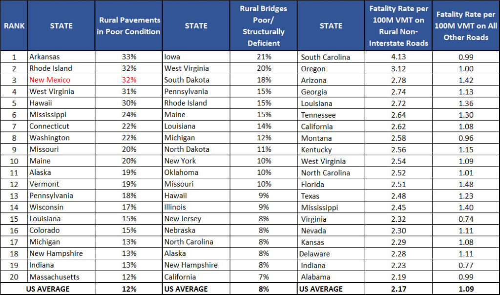
The report finds that New Mexico’s rural roads have significant deficiencies. Thirty-two percent of New Mexico’s rural roads are rated in poor condition – the third highest rate in the nation – and an additional 22 percent are in mediocre condition. Six percent of New Mexico’s rural bridges are rated in poor/structurally deficient condition. Bridges rated poor/structurally deficient have significant deterioration to the major components of the bridge and are often posted for lower weight or closed to traffic, restricting or redirecting large vehicles, including agricultural equipment, commercial trucks, school buses and emergency services vehicles. There were 155 fatalities on New Mexico’s non-Interstate, rural roads in 2020. Rural roads are more likely to have narrow lanes, limited shoulders, sharp curves, exposed hazards, pavement drop-offs, steep slopes and limited clear zones along roadsides.
America’s rural transportation system provides the first and last link in the supply chain from farm to market, connects manufacturers to their customers, supports the tourism industry, and enables the production of energy, food and fiber. Rural Americans are more reliant on the quality of their transportation system than their urban counterparts, with vehicle travel in rural communities averaging approximately 50 percent higher than in urban communities.
“Roadway safety countermeasures like median cable barriers, rumble strips and guardrails are among the most cost-effective ways to prevent traffic crashes and to save lives when they do happen,” said AAA traffic safety advocacy & research director, Jake Nelson. “At a time when our nation is recording record high traffic deaths, transportation investments ought to prioritize curbing traffic injuries where we can make the greatest impact—rural roads.”
Signed into law in November 2021, the Infrastructure Investment and Jobs Act (IIJA) will provide a significant boost in federal investment in roads, bridges and transit and offers an opportunity for the nation to make progress in improving the safety, reliability and condition of America’s transportation system. The IIJA will provide $454 billion over the five-year period from 2022 to 2026 for investment in highways and transit, resulting in a 38 percent increase in federal investment in 2022. The IIJA includes a $2 billion Rural Surface Transportation Grant Program that will support projects to improve and expand the surface transportation infrastructure in rural areas to increase connectivity, improve the safety and reliability of the movement of people and freight, and generate regional economic growth and improve quality of life.
“Farmers and ranchers depend on rural roads, highways and bridges to bring critical inputs like fertilizer and feed onto the farm and to move their products to market,” said Zippy Duvall, president of the American Farm Bureau Federation. “As recent supply chain challenges have highlighted, transportation delays and costs take a bite out of our profitability and competitiveness and impact the quality of rural life. Enactment of the IIJA will provide a significant boost to federal investment in roads and bridges and offers an opportunity to improve the safety, reliability and condition of America’s transportation system.”
An analysis of the Status of the Nation’s Highways, Bridges and Transit Conditions and Performance Report, 24 rd Edition report, submitted by the USDOT to Congress in 2021, indicates that the U.S. faces a $180 billion backlog in needed repairs and improvements to the nation’s rural roads, highways and bridges. This includes a $109 billion backlog for rural road and highway rehabilitation, a $35 billion backlog for needed rural bridge rehabilitation, and a $36 billion backlog for needed rural roadway enhancements.
“A reliable, safe, and well-connected transportation network is critical for American businesses, farmers and producers to reach important markets for their goods and to ensure the continued support and strengthening of our nation’s economy,” said John Drake, vice president for transportation, infrastructure, supply chain policy at the U.S. Chamber of Commerce. “The significant boost in federal investments to our highways, bridges, and ports provided by the IIJA will be vital for these Americans’ ability to remain competitive in the global marketplace while providing much needed improvements to our nation’s transportation system.”
“The health of the nation’s economy and the safety and quality of life in America’s small communities and rural areas ride on our rural transportation system,” said Dave Kearby, executive director of TRIP. “Providing the nation with a rural transportation network that supports rural America’s economy and will support its future development will require that the U.S. invest in a rural transportation system that is safe, efficient, and well-maintained, and that provides adequate mobility and connectivity to the nation’s rural communities.”

- Application Overview
- Mobile Overview
- Route Subscription Instructions
NMRoads Disclaimer:
The purpose of this website is to provide general information to the public about conditions on selected state routes. Because incidents and road conditions, whether attributable to traffic crashes or are weather-related, can rapidly change, this website may not reflect all incidents or road conditions for every route and should not be your only source for information. It should also be noted that reported road conditions are limited to those routes maintained by the NMDOT.
In some instances the information being provided is through a third party (i.e., weather conditions through the National Weather Service). The NMDOT is presenting this information as a service to its users and is not responsible for the accuracy or precision of the information they provide.
The website is intended to serve as a tool for planning your travel route and is not a guaranteed assessment of road conditions or incidents for any given time or location.
Close Disclaimer
Road Conditions
Please select, from the options below, the events that you would like to see.
- Road Closures A "Road Closure" indicates the roadway is temporarily closed.
- Severe Driving Conditions A "Severe Driving Condition" indicates the surface is mostly covered with frozen material. Limited or no visibility. Bridges and minor roads will likely be in worse conditions. Driving in these conditions can be dangerous. Please avoid driving if at all possible.
- Difficult Driving Conditions A "Difficult Driving Condition" indicates the surface is wet, but not yet freezing as of last report or has begun to clear since last report. Wet roads can be slick and may freeze suddenly. Often, salt and traffic will keep main roads wet while bridges or smaller roads are covered. Please use caution.
- Fair Driving Conditions The surface is generally dry and clearly. Watch for ice patches when temperatures are low. Frost can also cover dry pavement without warning. Drive carefully.
- Seasonal Closure Roadway is closed for the entire weather season.
- Crash A specific, identifiable, unexpected, unusual and unintended external motor vehicle event which occurs in a particular time and place, without apparent cause but with marked effect.
- Alerts Possible truck restrictions, permit status requirement, construction detour, etc. Be advised and use caution.
- Special Events Used for planned activities or events that potentially impact traffic or road conditions.
Construction
Please select, from the options below, the items that you would like to see.
- Road Work Any roadway maintenance or construction activity that could affect traffic
- Lane Closure Lane closed due to various reasons and for various time limits
- Construction Closure Road or facility closed due to construction
Weather Conditions
Surrounding states.
Please select, from the options below, the state that you would like to navigate to.
Hands Free Preferences:
- Include More Event Information Language: English Spanish Notify Radius (miles): 1 mile 2 miles 5 miles 10 miles 20 miles 50 miles 100 miles Notify Interval (minutes): 1 minute 5 minutes 10 minutes 20 minutes 30 minutes 60 minutes Activate / Deactivate

Road conditions from Reserve (New Mexico) to Show Low
Traffic from reserve (new mexico) to show low.

Please enable JavaScript
Train carrying fuel derails at Arizona-New Mexico state line, causes interstate closure
A train derailment at the Arizona-New Mexico state line is reportedly under investigation. The freight train was carrying propane and gasoline, according to The Arizona Department of Transportation.
The derailment, which happened Friday, is still causing major headaches for travelers. At one point, both directions of Interstate 40 near Chambers, Arizona were shut down. But now just the eastbound lanes remain closed. Drivers are currently being rerouted onto US 191 northbound.
The Arizona Corporation Commission posted to X , formerly known as Twitter, and said it was a BNSF train that derailed near Lupton, Arizona.
The New Mexico Department of Transportation posted on Facebook stating that the derailment in New Mexico happened near Gallup .
Tornadoes: Photos, videos show tornadoes in Nebraska, Iowa leave behind trail of destruction
Officials, Arizona Governor respond to train derailment
The Apache County Sheriff's Office posted on Facebook saying the derailment was "being treated as a hazardous materials incident" which lead to evacuation orders for nearby areas.
Arizona Governor Katie Hobbs posted Saturday on X, formerly known as Twitter, stating that she is concerned about the derailment and will be "monitoring the situation closely".
Investigation reportedly underway, no injuries
According to reports by multiple news outlets, the National Transportation Board (NTSB) and the Federal Road Administration (FRA) are currently investigating to figure out what lead to the train derailment.
Thankfully, there have been no injuries reported.
Navajo Nation impacted by train derailment
The Navajo Nation were a part of the evacuation orders issued because they were located within a two mile radius of where the derailment occurred. Additionally, the Navajo Nation police were one of the many agencies that responded to the incident.
The Navajo Nation President Buu Nygren issued a statement saying in part "Our deepest concern is for the safety and well-being of our citizens and those directly affected by this incident." The president also went on to say that they would cooperate with authorities and take any necessary precautions.
My Cameras Toggle
To add to My Cameras View:
- Map page - Click on a camera icon on the map, then click the "My Cameras" button at the top of the camera popup. Select from the Camera View list to add or de-select to remove.
- Camera page - Click on the three dots icon below the camera image to access the "My Cameras" option. Select from the Camera View list to add or de-select to remove.
- Closed/Stopped
Would you like to be notified of events on this route?
Default options for receiving Event Notifications:
- 6 AM - 6 PM

Freight train derails, catches fire near New Mexico-Arizona border causing road closures
A freight train detailed and caught fire, resulting in the closure of a nearby interstate, the Arizona Department of Transportation announced on Friday.
“I-40 EB is closed at milepost 357 due to a train derailment in New Mexico,” the Arizona DOT wrote on social media platform X . “Expect delays & seek an alternate route. There is no estimated time to reopen the highway.”
The train was carrying gasoline and odorless propane at the time of the derailment near Houck, Ariz. No injuries were reported as a result of the incident, according to New Mexico State Police .
Emergency crews were also on site to prevent the fire from spreading.
The cause of the derailment is unclear, and under investigation by BNSF Railway, notes The Associated Press reported .
“We’re monitoring the train derailment near the NM-AZ border closely – especially potential contamination from leaking hazardous materials,” Rep. Melanie Stansbury (D-N.M.) wrote on X .
Social media users described seeing the incident, with one X user writing , “Was crazy to see out of nowhere a fiery blaze shoot up in the sky.”
Friday’s derailment occurred just over a year since a Norfolk Southern train derailed in East Palestine, Ohio , and released a dangerous chemical — vinyl chloride — into the area. The incident, which thrust the railways in the spotlight, was only one of at least 29 occasions since 1968 during which toxic chemicals were released by a derailment.
For the latest news, weather, sports, and streaming video, head to The Hill.

IMAGES
VIDEO
COMMENTS
Looking for current road and weather conditions? Visit the NMDOT's 511 Travel Info system for up-to-the-minute road conditions. NMROADS. Go Back. NMRoads The Official Road Advisory System for the State of New Mexico. Do not use this mobile app while operating a motor vehicle. Ok, I am not driving. Dashboard ...
NMDOT General Office: 1120 Cerrillos Road, Santa Fe, NM, 87504-1149 | Telephone: (505)795-1401 | Road Advisory Hotline: 511 or (800)432-4269 NMOADS.com has been developed & is hosted & maintained by Real Time Solutions. Current time: Looking for current road and weather conditions? Visit the NMDOT's 511 Travel Info system for up-to-the-minute ...
Latest Road Conditions. Travel Alerts. Scenic Byways. Request a Map. Maps. Rest Areas. Places to See in New Mexico. NMDOT Park & Ride. Rail Runner Train Services.
NMRoads.com has been developed and is hosted and maintained by RealTimeSites, with contributing support from NMDOT and GIS staff. Surrounding States Road Conditions. NMRoads.com has been developed and is hosted and maintained by RealTimeSites, with contributing support from NMDOT and GIS staff. NMRoads.com has been developed and is hosted and ...
Alerts to crashes, road closures or other problem affecting traffic flows. Links to NM Rail Runner Express commuter train services and schedules Park and Ride locations for commuters in the Albuquerque and Santa Fe metro areas. Bicycle Routes and Trucking Information. Direct access to National Weather Service forecasts, maps and radar data.
Current road conditions including: current visibility, wind alerts, thunderstorms, tornado, flood alerts, and winder weather alerts. ... New Mexico Living Pet Pics April 26, 2024 Pet Pics ...
NMDOT is more than just roads - We are Aviation, Railroad and Ports. Additional activities and programs include research, active transportation (bicycle/pedestrian), traffic safety, transit and ports of entry. There are also links to data requests for traffic counts, functional classifications and crash data. Learn More.
We have also included a directory of the top sites for driving directions, and maps. We hope you find our site useful and informative and always drive safely. New Mexico: Road Conditions, Highway Conditions, Airport Conditions, Traffic and Transit Information. Road conditions and 511 traveler information phone number. 1 (800) 432 4269.
Plan your trip with SafeTravelUSA, the one-stop site for traffic and weather conditions across the US.
Plan Your Route. +. Track the weather and extreme weather situations along your route to make every trip a safe journey, whether it's sunny, rainy, or snowing.
A TRIP report states, "Vehicle travel on New Mexico's interstates increased 18% from 2000 to 2019." In addition to being frustrating, poor road conditions are linked to reduced safety, more ...
Albuquerque road conditions and traffic updates with live interactive map including flow, delays, accidents, traffic jams, construction and closures. ... Closure~~~The New Mexico Department of Transportation, in conjunction with the Federal Bureau of Reclamation wish to alert the travelling public to an upcoming roadway closure near the Navajo ...
Las Cruces. Route: Get up early and take the straightforward route to Las Cruces, New Mexico, on U.S. 62 toward El Paso, close to the border of Mexico. Along the Way. Upon Arrival. Detour: El Paso ...
To order a copy of the New Mexico State Road Map, please call 505-795-1401. NOTICE OF DISCLAIMER: Every effort is made to provide and maintain accurate, complete, and timely information. However, some data may be incomplete or outdated. Neither the New Mexico Department of Transportation, the State of New Mexico, nor any agency thereof, nor any of their employees, make any warranty, express or ...
The report finds that New Mexico's rural roads have significant deficiencies. Thirty-two percent of New Mexico's rural roads are rated in poor condition - the third highest rate in the nation - and an additional 22 percent are in mediocre condition. Six percent of New Mexico's rural bridges are rated in poor/structurally deficient ...
Check the road conditions from Santa Fe (New Mexico) to Las Vegas and plan a trip based on the weather along the way. ... Road conditions from Santa Fe (New Mexico) to Las Vegas. Enchanted Hills 66°F. Broken Clouds. Feels like 63.34 Wind speed 6 mph Pressure 1014 hPa. Albuquerque 67°F. Clear Sky. Feels like 64.89 Wind speed 3.4 mph Pressure ...
A hotline for those affected can be reached at 1-866-243-4784. | Local News from KRQE News 13 in Albuquerque, New Mexico
Check the road conditions from New Mexico to Arizona and plan a trip based on the weather along the way. Road Trip Conditions. Road conditions from New Mexico to Arizona. Traffic from New Mexico to Arizona. Milagro 58°F. Scattered Clouds. Feels like 54.91 Wind speed 23.9 mph Pressure 1003 hPa.
Check the road conditions near New Mexico based on the traffic and weather around New Mexico. Road Trip Conditions. New Mexico Road Conditions. Traffic conditions around New Mexico. Harkey Crossing 52°F. Overcast Clouds. Feels like 49.64 Wind speed 13.8 mph Pressure 1015 hPa
Fair Driving Conditions The surface is generally dry and clearly. Watch for ice patches when temperatures are low. Frost can also cover dry pavement without warning. Drive carefully. Seasonal Closure Roadway is closed for the entire weather season. Crash A specific, identifiable, unexpected, unusual and unintended external motor vehicle event ...
Traffic from Reserve (New Mexico) to Show Low. Reserve. 44°F. Clear Sky. Feels like 44.02. Wind speed 1 mph. Pressure 1016 hPa. NM 159 from milepost 4 to milepost 25 (Willow Creek Campground). STEEP GRADES AND NUMEROUS TIGHT TURNS.
A train derailment near Gallup, New Mexico and Lupton, Arizona at the Arizona-New Mexico border has led to the closure of Interstate 40. 📷 Key players Meteor shower up next 📷 Leaders at the ...
See the different types of permits below: Online Trip Permits. Weight Distance Accounts. Oversize/Overweight Permits. Commercial Boat Haulers - Call Before You Haul. NMDOT Permits. Utilities Accommodation. Checklist. Permit Application.
Traffic. My AZ 511. About. Developers. Provides up to the minute traffic and transit information for Arizona. View the real time traffic map with travel times, traffic accident details, traffic cameras and other road conditions. Plan your trip and get the fastest route taking into account current traffic conditions.
A freight train detailed and caught fire, resulting in the closure of a nearby interstate, the Arizona Department of Transportation announced on Friday. "I-40 EB is closed at milepost 357 due to ...