Table of contents

Santa Cruz Trek, Peru – A Guide to Hiking the Cordillera Blanca
Some of the links on this page are affiliate links
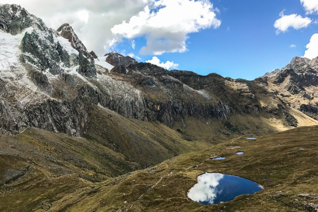
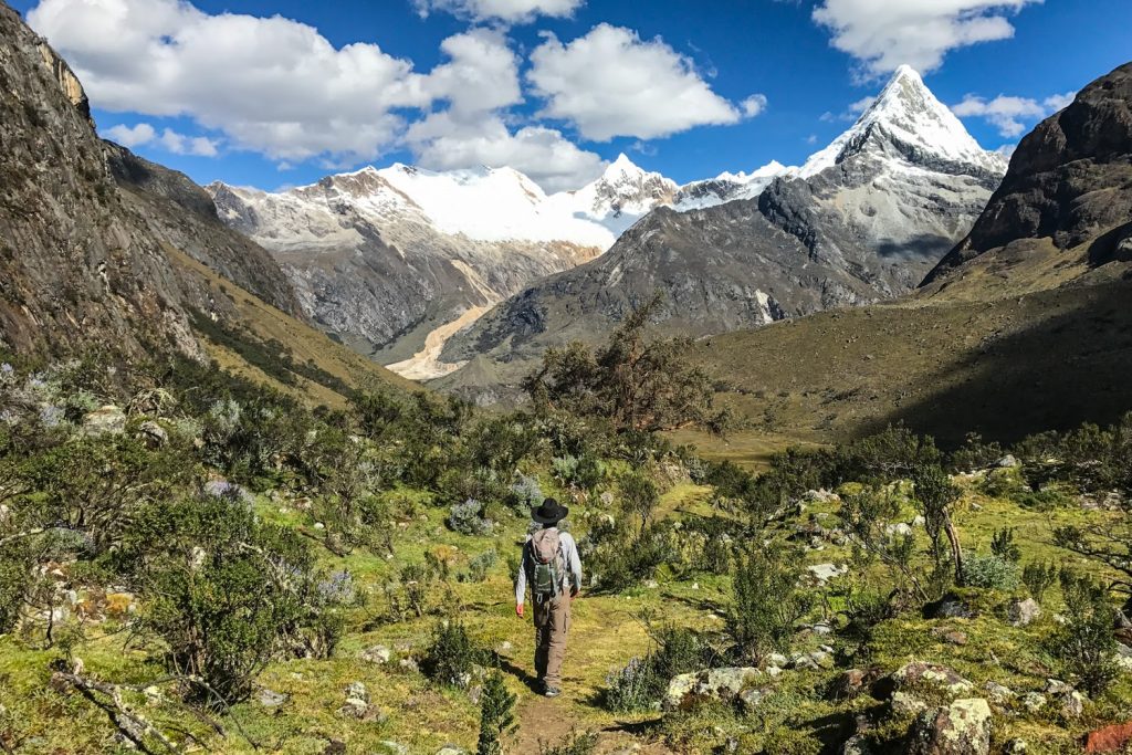
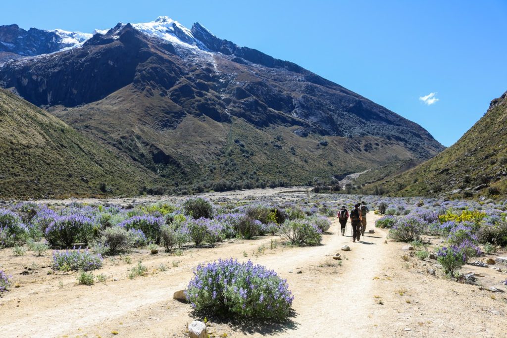
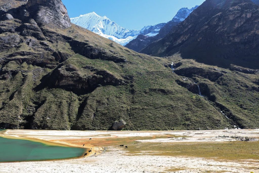
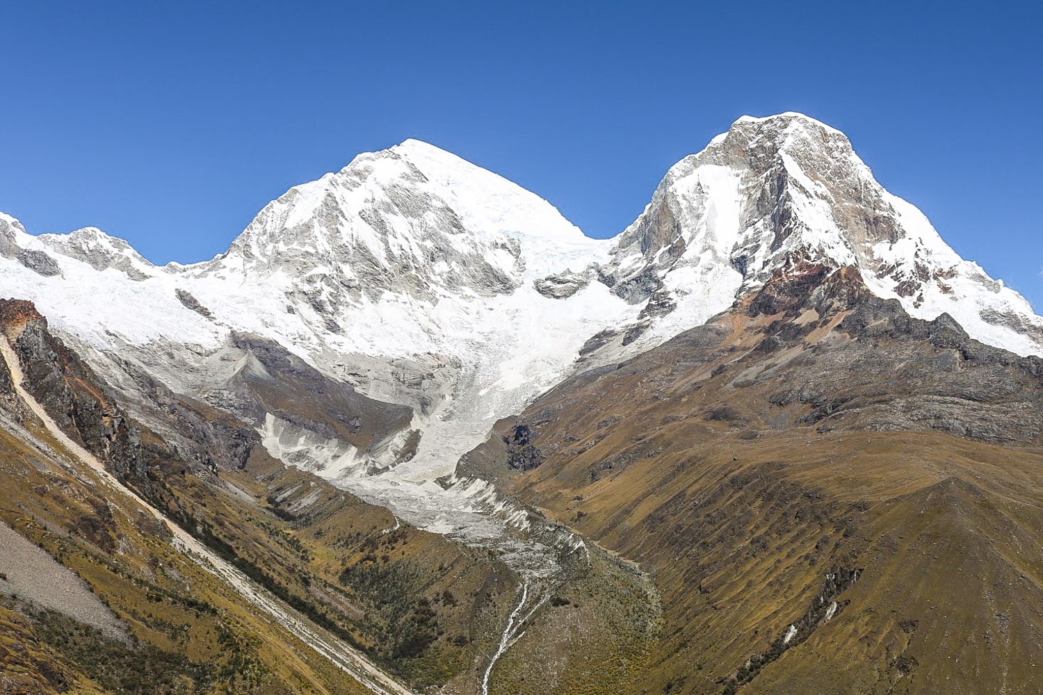
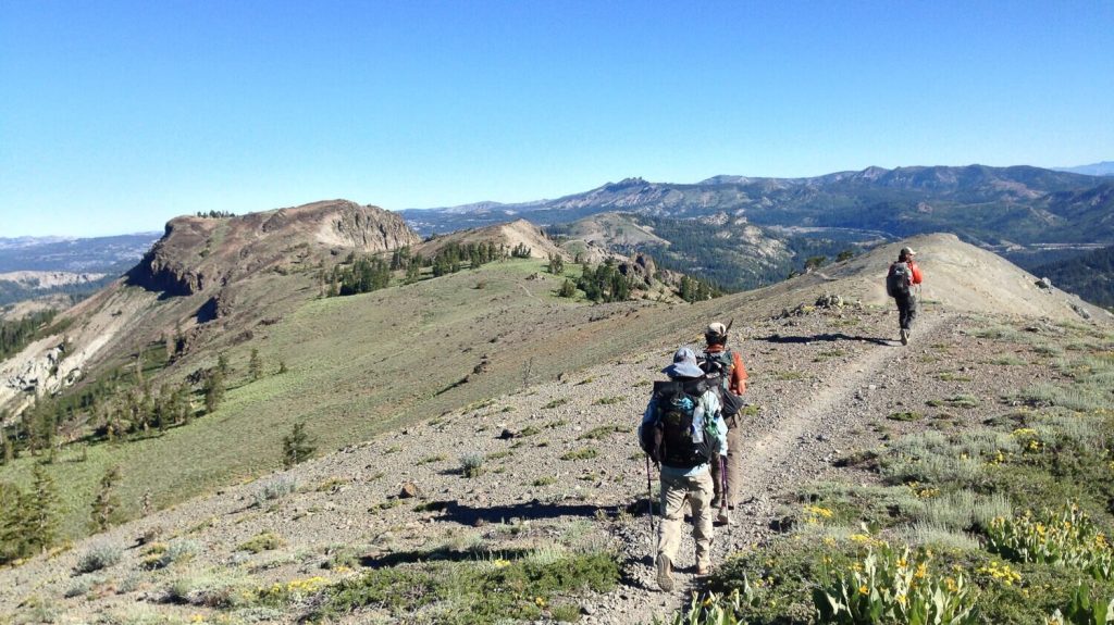
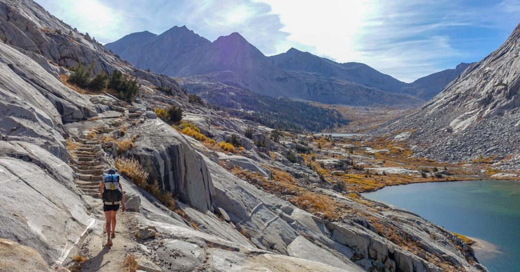
Nestled in the white-peaked Cordillera Blanca range in the Andes, the classic 4-day Santa Cruz backpacking trip may be one of the most beautiful treks in the world. While many people flock to the trails near Machu Picchu, this overlooked hiking mecca north of Lima has a fraction of the visitors, offering relative solitude for such a spectacular place. This trek winds its way through the valleys of the Cordillera Blancas while passing beautiful turquoise lakes on its way to the highest point on the trek, Punta Union.Whether you go independently or with a trekking company, this trek will leave you craving more for what this area has to offer.
Quick Facts
- Distance : 50 kilometers / 31 miles
- Days Needed : 3-4
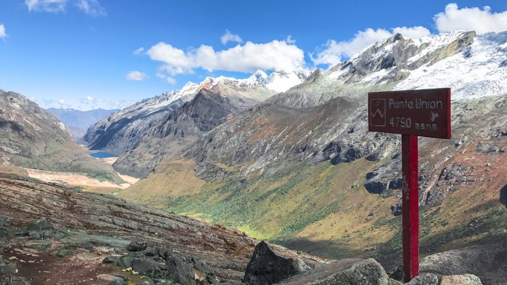
- Highest Elevation Reached : 4760m/15,617ft (Punta Union pass)
- Best Travel Time : May to September (dry season)
- Difficulty : Moderate-Difficult
- Closest Town : Huaraz
- Note : Can complete independently or with a guide
Best Time to Travel
Although people trek year round in this region, the best time to hike is May to mid-September when the weather is generally good and the mountains are clear. Hiking outside this peak season will bring much more solitude, but the weather is also more inconsistent. As always, make sure you check local weather conditions before you set out and be diligent in monitoring current conditions, as weather can change quickly in the mountains.
- Total Distance : 50 km / 31 miles
- Beginning elevation : Vaqueria (3700m/12,139ft) or Chashapampa (2900m/9,514ft)
- Highest elevation : 4,760m/15,617ft
- Overall Difficulty : Moderate-Difficult
As always, difficulty ratings depend on your experience, physical fitness, pack weight, & weather conditions. Each day you will be hiking for roughly 6-8 hours with moderate to significant elevation gain, depending on the day. If you are hiking with a guide or have a donkey to help carry some of your gear, you will be hiking with much less weight, allowing you to hike longer distances more comfortably.
We highly recommend training before your trek. Put a backpack on and do some day hikes. Get your body ready; do some air squats and lunges to build up leg strength. Know your limitations, brush up on your backpacking skills , and dial in your lightweight gear . Doing so will make for a much more enjoyable trip and can also help with altitude.
Getting There
Most people traveling to Peru arrive at Jorge Chávez International Airport in Lima. In order to begin the Santa Cruz trek you will need to get to the small mountain town of Huaraz, which lies 400 km north of Lima. You will have two options to get from Lima to Huaraz. You can take a bus, which takes roughly 8 hours and will cost you anywhere from $20-$30 depending on seat selection. We recommend going with either Cruz del Sur or Oltrusa , as they offer the most reliable, comfortable and cleanest buses. Also, you can buy your tickets online ahead of time, which is a rare convenience when traveling by bus internationally. Pro Tip: If taking a night bus, we highly recommend upgrading to a cama suite. Your seat will recline 180 degrees!
Your other transportation option is to fly from Lima to Huaraz, which takes about one hour and will cost anywhere from $85-$150, depending on season.
Visa Information
As of August 2017, you do not need a tourist visa to enter Peru. The maximum stay granted in Peru is 183 days. Please check current visa guidelines for specific information as these policies can change and this website is not an official source of information on Peru visas.
Where to Stay in Huaraz
You should spend 1-2 nights (we recommend 2 nights) in Huaraz prior to your trek in order to properly acclimatize. There are many hotels and guesthouses in all price ranges throughout Huaraz. We enjoyed staying in walking distance from Plaza del Armas, which is a central point in the small city. For around $30-40/night for two people, you can find very nice accommodation with breakfast included. Most hotels and guesthouses will store your larger bags for you while trekking.
We stayed at El Jacal Classic Guesthouse before our trek and were very pleased with the cleanliness and service provided. We arrived to Huaraz very early in the morning on a night bus and they let us hang out in the common area and even fed us breakfast that morning before check-in.
Pro Tip: Plan on spending a night in Huaraz after your trek to shower, relax, and drink a celebratory Pisco Sour with your new trekking friends. We had some people in our group that went straight from the trek to a night bus and they regretted it.
Trekking Cost
If you decide to complete the hike with a trekking company, you can expect to pay anywhere from $150-$300 for the 4-day trek. There’s a wide range in quality of service, so do your research. Usually a higher cost translates to better equipment, guides, food, and overall service. Compared to hiking costs in the areas around Machu Picchu, we felt the costs to hike around Huaraz were very reasonable for what you receive.
In addition to this cost, every trekker will be required to pay 65 Peruvian Soles (~$20 USD) in fees to Parque Nacional Huacarán. You can pay this at the trailhead prior to your trek. Just remember to bring a copy of your passport with you. It’s money well spent as your fee goes to maintain trails, pay park rangers, and continue conservation efforts in this breathtaking region.
Don’t forget to bring some extra cash with you. You may want to buy some treats after your get off the trail. You will also want some cash to tip your hard working guides, cooks, and donkey drivers. The going rate for tipping seems to be right around 10% of your cost, divvied up between all the trekking staff. Many groups pool their tips and give as a group.
There are two possible starting points for this trek and you can complete it in either direction. The most common place to begin is Vaqueria (3,700m), however on our trek we began at Cashapampa (2,900m). The benefit to beginning at Vaqueria is that it is less total elevation gain than beginning at Cashapampa.Also, if you are trekking independently, it is easier to finish at Cashapampa as there are more transportation options back to Huaraz. If beginning in Cashapampa, your first day is a hot and grueling climb up a dusty trail.
The benefit of beginning your hike in Cashapampa is that you have begin at a lower elevation and have a more gradual ascent to Punto Union, crossing the pass on your third day. For those struggling with altitude, this may be a better option. If properly acclimatized, we recommend starting at Vaqueria, if not, we recommend starting at Cashapampa.
If you are hiking independently, you will use a combination of combis (small buses) and shared taxis to get to the trailhead. It’s cheap and not super complicated to get to the trailheads. Just ask locally for the easiest transportation routes/options.
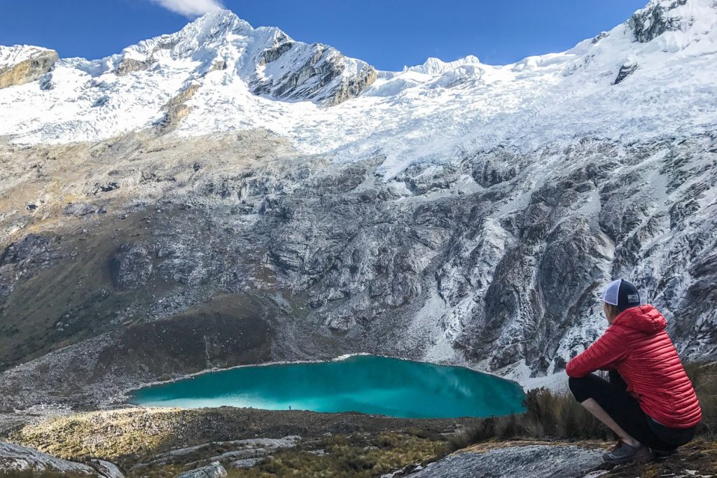
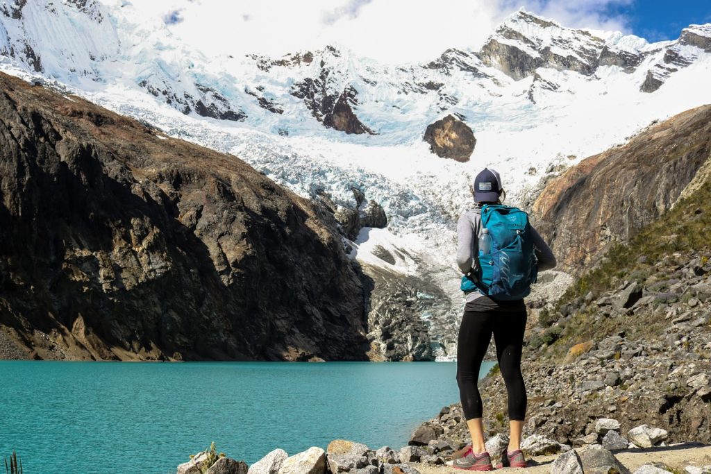
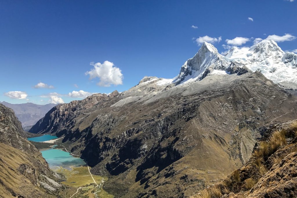
Regardless of where you choose to begin, there are some incredible side trips that you cannot miss. Either right before or right after you cross Punta Union, there is a side trip to Laguna Arhueycocha that is very worthy of the uphill sludge to get there. Think glaciers feeding into a beautiful turquoise lake surrounded by a amphitheater of peaks.
Independent or Guided Trekking
This is an important question for many trekkers and the choice will likely come down to experience and personal preference. Although we generally enjoy the freedom and flexibility that comes with hiking independently, when you factor in gear logistics, transportation, and the relatively low cost of going with a trekking company, we recommend hiring a guide for this trek. This does not mean you have to sign up for a trekking group with 14 other people. If you like the solitude of a small group, you could even hire your own guide and donkey driver, although your price will be higher.
If you’re a highly experienced backpacker, it is totally possible to complete this trek without a guide. The trail is well-marked and easy to follow.If you plan to hike independently, make sure you have a good map, the right gear, a proper permit, and a good guidebook before you leave Huaraz. Also, expect to put in a good amount of planning time to fully prepare for your hike. You will have to travel to Peru with a full backpacking setup or plan on renting quite a bit of gear in Huaraz. You will also have to carry all your gear, unless you hire a donkey driver.
If you’re unsure of your preparedness or nervous about high altitude safety, we highly recommend hiring a guide.
Guided Trek Pros
- all pre-trip details handled
- all transportation arranged
- little worry about any details while hiking (food, route, schedule, etc.)
- guidance & safety while trekking at high altitude
- local information on region, culture, etc
Independent Trekking Pros
- less expensive
- more flexible schedule
- more choice on where to camp
- no group dynamics to deal with, just you and the trail.
Trekking Companies
If you walk the streets in Huaraz, you will find no shortage of trekking companies. Many people organize their treks before arriving for peace of mind, however if you are on a more flexible schedule you can arrange your trek in Huaraz. After researching our options, we decided to go with the trekking company Eco Ice Peru . Their reviews were fantastic and our pre-trip communication with the owner, Orlando, was phenomenal. Throughout our trek we were constantly impressed with the professionalism and service offered at every turn. The staff was not only diligent in ensuring we had a good time, they were also fun, positive, and always smiling. After driving back to Huaraz on our last day we were invited to the house of Orlando’s mother and she served us a phenomenal feast with pisco sours. It was a lovely way to celebrate with our new friends.
There are plentiful water sources along the way, however it is imperative that you either boil or treat your water to ensure it is safe to drink.
If you are hiking with a trekking company, water will be provided for you every day on the trail. Every morning your crew will boil water and fill up your bottles for the day. We recommend bringing two 1L plastic water bottles per person. In addition, you will be provided with tea and other hot beverages at every meal time. Coca tea, which can help with symptoms of altitude sickness, will almost always be an option.
If you are hiking independently, we recommend bringing a SteriPEN Ultra as your water purification method. It is fast, easy to use, and you don’t have to ingest any chemicals. We also like the Sawyer Squeeze , as it’s incredibly lightweight, but the squeezing can become tedious. Aquamira Chemical Drops are also another good purification method, but they require time (30min – 4 hours) for purifying.
Remember: Staying hydrated is essential while trekking and it becomes increasingly important as you hike higher in elevation. Drink up!
If you are hiking with a trekking company, you will have all your meals provided, including a daily snack bag (chocolate, cookies, fruit, etc) and a tea time every afternoon which usually had delicious appetizers. The meals that we had on our trek were some of the best we had in Peru. Our dinners were often 3-4 course affairs, always including soup, several main courses, and dessert. It was amazing what the chefs would cook over a propane stove. We ate all our meals in a large tent, with a table and stools, a wild luxury on a wilderness trek.
The quality and quantity of food can vary between companies so ensure you do your research before selecting a company to go with. Eco Ice Peru was exceptional and we would highly recommend them.
If you are hiking independently, you will need to plan all your meals and carry your food and cooking system. For backcountry meals we usually focus on dehydrated foods like Mountain House, instant mashed potatoes, instant pasta, tuna/chicken packets, cured meats and hard cheese, and oatmeal, to name a few. One of our favorite fool-proof cooking systems is the JetBoil Mini Mo , which allow you to quickly boil water for meals and hot beverages.
For more information on food and meals in the backcountry, check out our video on Ultralight Backpacking Food .
Personal Hygiene
The Santa Cruz trek is a true wilderness trek so you should be prepared to get down and dirty. Some of the trekking companies provide a small bucket of hot water each day after hiking. However, we found that the best way to feel relatively clean was to pack a supply of body wipes . It’s amazing what a game changer this “shower” can be at the end of an arduous day of hiking.
Also, do not head out on the trail before picking up some alcohol-based hand sanitizer . Keep it in a handy place and use it before any snacks or meals.
Many of the trekking companies will put up a temporary toilet tent at your site every night. This is basically a small one-person tent with a dug-out hole for doing your thing. It’s not glamorous, but it ensures that human waste is disposed of responsibly and in a contained manner. Make sure that you carry toilet paper with you throughout the trek, as this is not always provided by your trekking company. As always, it is imperative that you Leave No Trace while trekking. Let’s help keep this place beautiful.
Mosquitoes and biting flies are present and can be incredibly obnoxious at lower elevations. Use a combination of permethrin on your clothing and a small amount of DEET on exposed skin for full protection. Luckily, bugs were only really an issue on the first and last days of the trek for us.
Travel Insurance
We highly recommend purchasing travel insurance if you plan to trek in Peru.Most trekking locations in Peru are very remote, so if something goes wrong, you’re likely to need an emergency evacuation and that can get insanely expensive.
When choosing travel insurance, make sure to buy a plan that will cover high altitude trekking and helicopter evacuations, just in case. We did a bunch of research and ended up choosing World Nomads for our treks. Their rates were reasonable, their coverage met our needs, and communicating with them was easy. We fortunately didn’t need to use our travel insurance, but the peace of mind alone was well worth it.
Trekking Safety
When hiking in Peru, you’ll be heading into remote areas far from reliable hospitals. If hiking with a trekking company, they will be carrying a basic first aid kit.If trekking independently, it’s important to take every precaution before you set out. Here’s a tutorial video we created to help you brush up on emergency first aid skills.
- Educate yourself on acute mountain sickness (AMS – more info below). Take the prescribed acclimatization days, stay hydrated, and listen to your body.
- We recommend buying travel insurance before you trek to ensure that if any emergency evacuations or procedures need to be completed, you are covered.
- Don’t trek alone. If you’re traveling solo, consider hiring a guide or making friends to hike with.
- Always pay close attention to weather conditions, especially on the long pass day. Storms can develop quickly in the mountains and can be fatal if you’re not prepared.
- Always hike with a lightweight first-aid kit and the 10 backpacking essentials .
- Leave a detailed itinerary with an emergency contact and write important phone numbers on a piece of paper that will be easy to find in an emergency.
- When encountering donkeys or mules on the trail, move to the inside (away from any cliff) and let them pass.
- Crime is not common while hiking in Peru, but it’s not unheard of either. Keep a close eye on your belongings, especially your backpack filled with valuables.
- Always carry enough water on the trail and stay hydrated.
- Keep your eyes on the trail to avoid any misstep that could end your trek.
High Altitude Safety
It’s important to know the basics of high altitude hiking. Acute Mountain Sickness (AMS) is no joke, and if you make reckless decisions or ignore symptoms, it could even kill you. Most people that take the time to acclimatize properly experience limited AMS symptoms, if any, so there’s no need to freak out. But you do want to understand AMS and take it seriously. Learn more about high altitude safety with this tutorial video we created.
Although this trek has a gradual ascent, you will be hitting an elevation of 15,617 ft (4,670m), which is significant for the average hiker. Many people coming to Peru are arriving from near sea level and will need to take a few days in Huaraz (10,013 ft/3,052m) to acclimatize prior to heading out on the Santa Cruz Trek. It’s recommended that you go on several day hikes to prepare. The day hikes around Huaraz will most likely be some of the most beautiful day hikes you’ve ever done. Some recommended acclimatization hikes in the area are: Laguna 69, Laguna Wilcacocha and Laguna Churup.
Maps and Guidebooks
- Lonely Planet Peru – For general trip planning and research, we highly recommend picking up this book. There’s good information about the Cordillera Blanca region, including the Santa Cruz trek, day hikes around Huaraz and general information on Huaraz. And I’m sure you didn’t come to Peru just to hike in the north. It’s the travel bible. Pick one up.
- Peru’s Cordillera Blanca and Huayhuash: The Hiking and Biking Guide – This book is a great resource written by people who’ve actually hiked and biked these trails. If you chose to trek independently, this is a resource you should definitely consider purchasing. It covers the Santa Cruz and Huayhuash treks extensively, but also offers great information on lesser known treks in the region.
- Map of Santa Cruz Trek (From Cashapampa to Vaqueria) – This is a somewhat basic map of the area that will give you a general outline of the trek. You will want to find a more detailed map in Huaraz to take on the trail if you are hiking independently.
Trekking Gear List
One of the nicest things about trekking in Peru is that it’s accessible for a wide range of travelers. Most of the people that come to Peru to trek do so with a trekking company, which will provide most of the camping and cooking equipment, transportation and food. In most situations you will be provided with a duffle bag the night before you depart for your trek. It varies, but generally you are allowed to fill this bag with 5 kgs (~11 lbs) of gear that will be carried by the donkeys during the day. Because most of your gear is carried by donkeys, you should be carrying a pretty light daypack. That will give you the opportunity to pack light and enjoy your hike. If you’re new to our site, don’t miss out on the CleverHiker Gear Guide , where we break down our favorite tents , sleeping bags , sleeping pads , backpacks , stoves , hammocks , and much more.
DAYPACK – A simple lightweight daypack (20-30 liters) is really all you should need on a supported trek. We used the Osprey Talon 22 Daypack and were incredibly happy with it. It was lightweight, provided the perfect amount of space, and had the comforts of a larger hiking backpack (sturdy hip belt and sternum strap, ventilated back). The items in your daypack will include water, snacks, layers, camera equipment, sun protection, and any other items that you will need accessible throughout the day.
SLEEPING BAG – Although most of your gear is provided by trekking companies, oftentimes you are required to bring your own sleeping bag or rent one from the company. The quality and cleanliness of rented bags can vary significantly so we recommend, if you have the space, bringing your own sleeping bag. The trekking companies recommend a sleeping bag rated in the 10-20 degree range. We used the Feathered Friends Egret UL 20 and REI Magma 10 sleeping bags. They were plenty warm on chilly nights and we enjoyed the comfort of not sleeping in someone else’s filth. Here’s a list of some of our other favorite lightweight sleeping bags .
SLEEPING PAD – If you are trekking with a company, they almost always provide a sleeping pad, but always double check. If not, we recommend a lightweight sleeping pad such as the Therm-a-Rest NeoAir XLite that will keep you warm and ensure a good night’s rest.
SHOES OR BOOTS – We almost always prefer trail runners when hiking. We wore my Saucony Peregrine 7 trail runners , which come in male and female versions, on all of our Peru treks and we’d make the same choice again. If you prefer boots, make sure they’re lightweight and break them in really well before you set off on the trail. Here’s why we prefer to hike in trail running shoes: 5 Reasons to Ditch Your Hiking Boots .
WATER PURIFIER – If hiking with a trekking company, you do not need to worry about bringing a water purifier as you will be provided with boiled water.If hiking independently, we recommend the SteriPEN Ultra . It’s fast, easy, and effective. You’ll also save money and waste a lot less plastic by reusing the same bottles. Purifying tablets are easy to find in Peru, but we prefer not to ingest strange chemicals whenever possible. We picked up some tablets to have as a backup but thankfully didn’t end up needing them.
CLOTHING – Don’t overpack on clothing. That’s a common mistake that will lead to unnecessary weight. Instead, pack in layers and avoid bringing any two items that will serve the same purpose. Here’s what we brought with links to some of our favorite gear:
- 1 Rain jacket shell – Patagonia M10
- 1 Pair rain pants – Mountain Hardwear Stretch Ozonic
- 1 Down jacket – Patagonia Ultralight Down Hoody
- 1 Fleece jacket – Extra warmth under your down jacket that will be warmer when damp and better to hike in.
- 1 Pair hiking pants / running tights
- 1 Pair hiking shorts – Nike dri fit running shorts
- 1-2 Hiking t-shirts – Nike dri fit t-shirts
- 1 Long-sleeve shirt – Nike dri fit quarter zip
- 1-3 Pair underwear – ExOfficio boxer briefs or ExOfficio women’s briefs
- 2-3 Pair socks (add thin sock liners if using boots) – Balega running socks for warm weather & SmartWool mountaineer socks for snow.
- 1 Pair long john bottoms – long john top optional for nighttime use.
- 1 Pair gloves or mittens
MAP, COMPASS & GUIDEBOOK – You can find a trekking map in Huaraz, as well as in the guidebooks. We always hike with a compass too, though the trails were easy to follow and we didn’t end up needing it. For a guidebook, we found the Lonely Planet Peru to be very useful.
FIRST-AID KIT – Always bring a small personalized first aid kit. We used the .5 Ultralight Kit and added extras, like painkillers, diamox, and personal medications.
SUN PROTECTION – Sunglasses (polarized recommended), sunscreen, and spf lip balm are an absolute must.
HEADLAMP – A small headlamp like the Petzl Actik will be useful for late night bathroom visits.
POCKET KNIFE – We brought along a small Swiss Army Knife which came in handy here and there. This should be considered optional, but we like to hike with one.
PACK COVER – We don’t hike with pack covers because they don’t provide full rain protection. We use a combination of waterproof stuff sacks and a sturdy trash bag liner inside our packs. That gives us 100% rain protection, even in a downpour. Ziploc bags also come in handy.
TREKKING POLES (optional) – We don’t usually hike with trekking poles, but many hikers in Peru do. If you have bad knees/ankles they can help reduce strain on big ascents and descents. We didn’t bring them on any of our treks in Peru and didn’t miss them at all.
OTHER ITEMS
- SMALL TOWEL – the Nano pack towel is great.
- CASH and COPY OF PASSPORT
- PERSONAL TOILETRIES
- HAND SANITIZER – Use hand sanitizer often (especially before meals) and you’ll have a better chance of avoiding illness.
- WET WIPES – These are very useful for cleaning up after hiking, especially when it’s too cold for a shower.
- INSECT REPELLENT – At higher elevations insects aren’t a problem at all. For lower elevations, 30% DEET will do the trick.
- BIODEGRADABLE SOAP – A small bottle of Campsuds can be useful for washing up and cleaning clothes.
- TOILET PAPER – Most trekking companies won’t provide any, so you’ll want to bring your own.
- GEAR REPAIR TAPE – Tenacious Tape is great for many different issues that may arise.
- CAMERA – The Sony RX100 is our go-to camera for backpacking.
- POWER BANK – We kept all our electronic devices charged with a power bank . The batteries on your phone and camera will drain more quickly at high altitude, so it’s essential to have a backup power source.
- GAMES, BOOKS & JOURNAL – There can be some afternoon downtime when hiking in Peru, so make sure to bring lightweight entertainment. We loved having our Kindle Paperwhites with us. We also played cards, worked on crossword puzzles, and wrote in our journals often.
- SNACKS – Don’t overdo it, as your trekking company will be giving you a daily snack bag. That said, having a few luxury snacks can be nice. We’re big fans of a daily Snickers on the trail.
- EAR PLUGS – You may have a snorer in your group, so we always travel with a lightweight pair of ear plugs . They are also great if you are taking any long bus rides.
- WATER BOTTLES – We hiked with two 1L plastic water bottles each. They’re cheap, strong, they work well with the SteriPEN, and they’re easily replaceable. Water sources are plentiful along trails and we rarely needed to hike with more than 1-2L each.
INDEPENDENT HIKING GEAR
If you are heading out on the Santa Cruz independently then you are a probably an experienced backpacker and are aware of your gear requirements for multi-day treks into the mountains. That being said, there is a good amount of elevation gain on this trip so it is imperative to keep your pack weight to a minimum. We prefer lightweight backpacking because it’s more comfortable and it allows us to cover more ground with less effort. It makes the hiking a lot more fun and trip logistics a lot easier. But we don’t like giving up camp comforts either. We hike with lightweight shelters , plush sleeping pads, cozy sleeping bags , and all the other camp comforts everyone wants. For recommendations on our favorite lightweight backpacking equipment, check out the CleverHiker Gear Guide and our Top Gear Picks page.
Responsible Trekking & Cultural Considerations
The number one rule of backpacking is Leave No Trace . Learn it and live it. Don’t litter. Pack out your trash and keep Peru beautiful for generations to come. If you really want to be a superstar, pack out trash that you find along the trail. Dispose of human waste properly (dig a hole 6-8 inches deep, fill it back up when finished, and carry out your toilet paper). Dress conservatively, especially in towns. For women, this may mean hiking in long pants rather than short shorts. Always ask permission before taking a photo of a person. Most people won’t mind, but if they decline, respect their wishes.
Santa Cruz Photo Gallery
Why trust us?
We understand how tough it is to find trustworthy gear advice, and that’s one of the main reasons we built CleverHiker. We live for outdoor adventure, and we take these guides very seriously.
- Our recommendations are completely independent and based on hands-on experience.
- We test outdoor gear for a living – we’ve logged over 20,000 trail miles and 1,000 nights in the wilderness.
- Our team has thru-hiked some of the most iconic long trails, including the Continental Divide Trail, Pacific Crest Trail, Appalachian Trail, Colorado Trail, Long Trail, Oregon Coast Trail, Arizona Trail, Pinhoti Trail, Superior Hiking Trail, as well as extensive peak bagging, and international treks.
- We field test every product we recommend, which is sadly not the norm.
- We travel to industry trade shows to stay up-to-date on product innovations.
- We continuously update our guides throughout the year and when new products launch.
- We treat recommendations to our readers as if they were for our family and friends.
- We’re lifelong learners and we’re always open to feedback. If you think we’ve missed a worthy product or got something wrong, we’d love to know about it.
Related Content
Strawberry Mountain Wilderness Loop Backpacking Guide
A Complete Guide to Hiking the Colorado Trail
A Quick Guide to Thru-Hiking the Pacific Crest Trail
Teton Crest Trail Backpacking Guide
The Ultimate Guide to Vermont’s Long Trail
Glacier National Park Backpacking Guide
A Complete Guide to Hiking the John Muir Trail
Three Fingered Jack Loop Backpacking Guide
McKenzie River Trail Backpacking Guide
A Quick Guide to Thru-Hiking the Continental Divide Trail
A Guide to Hiking in Torres del Paine: W, O, and Q Treks
A Quick Guide to Thru-Hiking the Appalachian Trail
Get the best content from cleverhiker & around the backpacking world.
Social media is great, but our bi-weekly newsletter is a much better way to stay in the know.
Sign up to get our curated emails with the best content from CleverHiker and around the backpacking world. You’ll be turned on to new videos, trip reports, gear reviews, inspiring outdoor stories and much more. So get in the mix!
- Call Us: +51 43 423733
- Departures 2024

Cordillera Blanca
Cordillera Blanca Located in Ancash, it is the world’s highest tropical mountain range. Almost the entire mountain chain is protected by the Huascarán National Park, an area home to 663 glaciers, 269 lakes and 41 rivers, in addition to 33 archaeological sites. The Cordillera Blanca is riddled with countless trekking circuits. However, some of them have become world-famous: the route of the Quebrada Santa Cruz gully is possibly the most popular of all. The trek sets out from Cashapampa and ends up in the gorge of Quebrada Llanganuco, at the edge of the emerald-green waters of the Llanganuco lakes.

Olleros - Chavin Trek
The Olleros – Chavin trek is a great alternative way to reach and visit Chavin, a relatively famous archelogical site. The trek leads across a southern pass of the Cordillera Blanca called Punta Yanashallash (map – to the middle right).

Pastorury – Chavin trek
The surrounding mountains, known as the Black and White Cordillera for their contrasting colors, are exceptionally beautiful. The valley between these two mountain ranges is commonly known as the “Callejon de Huaylas”.

Quilkayhuanca – Cojup trek
Quilcayhuanca trek – trekking Quicayhuanca This is a trail that is becoming more popular with time, due to the beauty of these 2 valleys, surrounded by peaks of 6000 masl, and the spectacular lagoons such as Palcacocha and Cuchillacocha.

Santa Cruz Trek – Vaqueria – Llanganuco
Santa Cruz Trek / trekking santa cruz one of the most popular hiking trails in the cordillera blanca . it is popularity is due to the spectacular mountain views , crystal lake and challenging passes.

Santa Cruz – Ulta Trek
The Santa Cruz – Ulta Trek is an extension from clasic santa cruz trek , the extension trail start from Huaripampa valley in this trek we have two amazing high passes as punta union at 4,700m.

Quilkayhuanca – Cojup – Ishinca Trek
Quilkayhuanca Cojup Ishinca trek is a trail that is becoming more popular with time, due to the beauty of these 2 valleys, surrounded by peaks of 6000 masl, and the spectacular lagoons such as Palcacocha and Cuchillacocha.

Circuit cedros – Alpamayo Pomabamba
The cordillera Blanca must provide one of the most varied landscapes for trekking and climbing in the world.

Circuit Cedros – Alpamayo - Llanganuco
Along this trek we will see the pyramid of Alpamayo mount at 5,947 the which has voted the most beautiful the world The trek circuit Cedros – Alpamayo is one of the most scenically spectacular walking routes of the Andes.

Circuit cedros – Alpamayo- Ulta
Circuit Cedros Alpamayo Ulta Llanganuco .The cordillera Blanca must provide one of the most varied landscapes for trekking and climbing in the world.

Alpamayo Base Camp Trek – Alpamayo Guided Treks
The Alpamayo base camp Trekking is a combination of the Santa Cruz Trek and circuit Cedros Alpamayo in the stunning Cordillera Blanca / White Range in Peru.

Olleros - Carhuascancha – San Marcos – Chavin Archaeological Site
The Olleros Carhuascancha Chavin trek, the less known, unique and remote hiking trail in the conchucos valley. we can say unspoiled area within in the Cordillera Blanca.

Pisco Base Camp and Lake 69 Trek – Llanganuco Tours
Pisco Base Camp Trek combines with 69 Lake in the Llanganuco valley within Huascaran National Park.

Ishinca Valley - Refugio Don Bosco en Los Andes
Short trek to Tocllaraju base camp, experience the 360-degree views in the Ishinca base camp on our 3 day Ishinca Valley trek.

Santa Cruz – Lake 69 and Llanganuco Lakes
Santa Cruz trek and 69 lake trek is one of the most beautiful popular and challenging trekkings in the Cordillera Blanca - South America is one not to be missed!

Women’s Trekking Santa Cruz to Llanganuco with Female guide
Peruvian Mountains presents women trek Santa Cruz to Llanganuco + 69 Lake is designed for female travel groups in Peru.

Family Holidays
Welcome to all of our Adventure Treks families. If you are looking for an adventure packed Family Camping, Hiking for Family, Family Adventure Holiday, Family Romantic Destinations, Peruvian Mountains is your best option.
The Hiking Life
A Quick & Dirty Guide to the Cordillera Blanca Traverse
Posted on August 4, 2022 February 12, 2023 Author Cam 16 Comments
In the summer of 2014, I put together a traverse of Peru’s Cordillera Blanca. One of the world’s highest and most beautiful mountain ranges, to the best of my knowledge, it was the first time that such a trek had been completed.
Beginning at the village of Hualcallan and finishing at Pastoruri Glacier, the route consisted of a combination of established trails, cross-country scrambles, and the occasional stretch along backcountry dirt roads. Measuring approximately 400 km (249 mi) in length, it took 16 days to complete and included more than 20 mountain passes ranging between 4,347 m and 5,201 m (14,262 ft-17,064 ft). After eight years and quite a few requests, I’ve finally put together a “quick & dirty” guide for the route (no point rushing these things 😉 ). The article includes GPS data, logistical tips, alternates, and trekking notes for the route’s four stages.

Views from just below Ishinca Pass (5,201 m), the highest point on the CBT (Stage 2).
CBT Shout-outs : Before getting started, I’d like to mention two people in regard to the CBT – Austin Lillywhite and Ryan “Dirtmonger” Sylva. The former completed three of the trek’s four stages in 2017 and was kind enough to provide information on a couple of alternate routes. The latter is an old friend who, along with a pair of mates (Bobcat and Stef), completed the CBT in 2018 and has contributed updated logistical information, photos, and route options from their journey ( Note : For more on Austin and DM see online resources below).
At a Glance
Cordillera Blanca Miscellanea
One Route, Four Stages
National Park Permit
- How Long will it take?
Pre-CBT Acclimatization Strategy
Water & Resupply
Camping & Accommodation
- GPS & Maps
Online Resources
- Trekking Notes: The Passes
- Stage 1: Hualcallan – Pompey/Huallin
- Stage 2: Huallin – Pitec
- Stage 3: Pitec – Chavin
- Stage 4: Chavin – Pastoruri Glacier

Nearing Paso Yanayuca (photo courtesy of Ryan “Dirtmonger” Sylva) (Stage 1)
Distance : 249 miles (400 km) approx.
Average Duration : 16-22 days
Start / Finish :
- Northern Terminus : Hualcallan (3,133 m/10,279 ft)
- Southern Terminus : Pastoruri Glacier (5,033 m/16,512 ft)
Highest Elevation : Ishinca Pass (5,201 m/17,064 ft)
Lowest Elevation : Hualcallan (3,133 m/10,279 ft)
Total Elevation Gain : 25,417 m (83,389 ft)
Highlights:
- Nevado Alpamayo at sunset
- Ishinca and Cashan Passes
- The archeological site of Chavin de Huantar
- Puya Ramondii around Lake Qishqiqucha
- Regenerating swims in bone-chilling alpine lakes
- The friendliness and hospitality of the Cordillera Blanca’s residents

The pyramid-shaped Alpamayo (5,947 m/19,511 ft) illuminated by the late-afternoon sun (Stage 1)

Growing up to 10 m (33 ft) high, Puya Raimondii plants are endemic to the high-altitude regions of the Peruvian and Bolivian Andes. They are the world’s largest Bromeliad and are known as the “Queen of the Andes.” (Stage 4)
- Situated in the Ancash region of Peru, the Cordillera Blanc a is a sub-range of the Andes mountains. It’s approximately 13 miles wide (21 km) and 124 miles (200 km) long as the condor flies.
- The Cordillera Blanca contains a dozen peaks that are higher than 20,000 ft (6,096 m), with a further twenty-four topping 18,000 ft (5,486 m).
- There are estimated to be 722 individual glaciers within the Cordillera Blanca range, which is the largest concentration of tropical-zone glaciers on the planet. Since the 1970’s they have retreated more than 15%. A staggering reduction, especially considering their hydrological importance to a growing Peruvian population.
- In 1970, the Cordillera Blanca was rocked by an earthquake (7.9 on the Richter scale) that wiped out 95% of Huaraz (the regional capital), completely destroyed the town of Yungay, and was responsible for the deaths of up to 70,000 people. It was the worst natural disaster in Peru’s history, and the resulting avalanche is considered the deadliest in world history.
- For history buffs such as myself, a not-to-be-missed side trip during the CBT is the historic village of Chavin de Huantar . Located on the eastern flanks of the Cordillera Blanca, in addition to its picturesque plaza and dramatic setting, Chavin is home to a World Heritage-listed archeological site that dates back more than 3000 years. Chavin de Huantar was the religious center of the Chavin people, one of the major pre-Inca cultures of Peru.
- Legend has it that Artesonraju Peak (6025 m/19,767 ft) is the inspiration behind the famous Paramount Pictures icon. A few miles north of there lies Nevado Alpamayo , a pyramid-shaped mountain that was voted the world’s most beautiful mountain by an international survey commissioned by the German Alpine Club in the 1960s.

Cordillera Blanca Range Overview Map
For the purposes of resupply, I split the CBT into four stages (click on the links below for journal entries from 2014). Each of the stage trailheads is accessible by public transport, meaning that folks that aren’t interested in thru-hiking the CBT could potentially do one or more of the stages as stand-alone hikes ( Note : Distances have been updated as of 2022, and will vary depending on route choices):
- CBT Stage 1 – Hualcallan to Pompey/Huallin (152 km/94 mi)
- CBT Stage 2 – Pompey to Pitec (108 km/67 mi)
- CBT Stage 3 – Pitec to Chavin (65 km/40 mi)
- CBT Stage 4 – Chavin to Pastoruri Glacier (72 km/45 mi)

Cordillera Blanca Traverse – Google Map Overview
The CBT takes place in Parque Nacional Huascarán. For any multi-day hike in the park, you’ll need to obtain a trekking permit from their office in Huaraz (-9.53203, -77.52984) before setting out.
- May to September is the dry season in the Peruvian Andes. Technically speaking, this is late autumn/winter in the southern hemisphere, however, due to the fact that the Cordillera Blanca is situated so close to the equator, temperature fluctuations are relatively minor throughout the year. I hiked from late August to early September and had fine weather throughout most of the 16 days. Temperatures ranged between highs around 20°C and lows of -10°C ( Note : The latter was experienced when camping just below 5,000m).
- What’s too early? What’s too late?: Obviously, conditions will vary from year to year, but given average annual snow levels, I wouldn’t recommend starting the route before early June or later than the end of September. A case in point is Austin Lillywhite’s May 2017 hike, where he was unable to go over Stage 3’s Cashan Pass because of snow conditions.

Cashan Pass in late August (5,157 m/16,919 ft) – One of the toughest of the CBT’s 21 passes, Cashan may be snowbound early in the hiking season ( Note : The southern side of the pass still had quite a bit of ice/snow when this photo was taken) ( Note 2 : The pass is the little notch in the centre of the photo)(Stage 3)
How Long Will it Take?
- My CBT Experience : I took 16 days to complete the CBT. Some of those days were spent route finding, visiting archeological sites, and generally checking out other points of interest along the way. I took one complete “zero-day” (rest day) in Huaraz and another “nero” (almost a zero) in Chavin. Pushing a little bit harder and without the diversions, route-finding, and rest day, I suspect I would have taken around 13 days to complete the hike.
- Average Duration : This is a route that should only be undertaken by experienced long-distance hikers who begin the trail well and truly acclimatized. If you tick those boxes, along with turning up in good shape and carrying a lightish pack, I’d estimate the average time needed for the CBT would be between 16 and 22 days (including a rest day or two).

Laguna Cullicocha (4,620 m) – The first of many lakes along the route (Stage 1)
After the initial climb out of Hualcallan, almost all of the CBT takes place above 4000 m (13,123 ft). I can’t emphasize strongly enough that this is a hike for which you need to be well-acclimatized before setting out.
In order to avoid possible issues with AMS ( Acute Mountain Sickness ), plan to spend at the very least two or three days in Huaraz (3640m / 11,942 ft) before beginning the CBT. During your stay in the regional hub, do some short excursions such as the Laguna 69 (-9.01074, -77.61178) and Laguna Churup (-9.48503, -77.42871) trails, both of which are easily accessed via public transport from Huaraz. If you have the time, I’d also suggest hiking the nearby Cordillera Huayhuash Circuit before the CBT. For more information on acclimatization, see Tips for High Altitude Hiking .

Snow-capped horizons near Alto de Pucaraju (4,615 m) (Stage 1)
- Northern Terminus : Hualcallan Village. I took a collectivo (minibus) from the town of Caraz to the village of Cashapampa, from which I walked nine kilometers to Hualcallan. If you want to go directly to Hualcallan, private transport/taxi can be arranged from Caraz.
- Southern Terminus : Pastoruri Glacier is a popular destination for day-trippers from Huaraz. If you arrive before late afternoon, there should be no issues getting a place on one of the buses that regularly ply the route to and from the regional capital.
- From the end of Stage 1 , you can either hitch or take one of the regular buses that pass by to the nearby village of Chacas . Returning to the trail, catch a bus bound for Huaraz, and ask to be dropped off at Pompey/Huallin.
- From the hamlet of Pitec at the end of Stage 2 , you can catch a ride down the mountain to Huaraz. Alternatively, walk west for a further 4.5 km to Llupa and take one of the regular collectivos that leave from there.
- From the end of Stage 3 on Road #110 overlooking Lago Querococha, hitch or flag down one of the regular buses that head eastwards to the village of Chavin de Huantar.

The village of Hualcallan is the starting point of the CBT. This photo was taken from the switchbacks above the village.

The rapidly-shrinking Pastoruri glacier, the southern terminus of the CBT.
- Water : Abundant throughout most of the hike. Generally speaking, I treated with Aquamira in the low-lying areas and/or wherever there was livestock or human settlement. In the higher reaches, where water was coming directly off the glaciers, I drank straight from the source. I had no intestinal issues on this or any other hike I’ve done during my trips to Peru.
- Resupply : From north to south, the main resupply points are Huallin, Chacas, Pitec (Huaraz), and Chavin de Huantar (see Transport above). The regional hub of Huaraz has a wide range of “traditional backpacking” food available, such as dried fruit and nuts, cereals, pasta, tuna, powdered milk, chocolate, etc. Choices are much more limited in the villages along the way. On the cooking front, you’ll be able to pick up a gas canister or denatured alcohol for your stove in Huaraz.

Meandering stream in Quebrada Honda (Stage 2)
On the route itself , you can wild camp pretty much wherever you like. That said, I’d avoid setting up too close to villages or shepherd encampments (which may be patrolled by territorial guard dogs).
There’s one full-service mountain hut along the route – Refugio Ishinca. Situated in the shadows of Toclarraju (6,032m) and Polcaraju (6,110m) peaks, Refugio Ishinca was an unexpected bonus. Half expecting a semi-dilapidated backcountry outpost, what I got instead was comfy beds, good food, helpful staff, and even a solar-powered shower!
In Town : The regional capital of Huaraz has a multitude of options to suit all budgets. During my time in town, I stayed at the Hotel Churup, which I can highly recommend. Juan Quiros Romero and his family were excellent hosts, the breakfasts were first-rate, the rooms comfortable, and they stored my extra luggage when I was out in the boonies. Double thumbs up.
Regarding the other towns along the route, in Chacas , I arrived late and ended up staying at a dodgy place whose only redeeming feature was that it was centrally located. As for Chavin de Huantar , I stayed at the characterful Hostal La Casona on the Plaza de Armas. I’m 99% certain that this was the same place I stayed at in 1996, and for the sake of nostalgia, I couldn’t resist returning 18 years later. On the remote chance that they are reading this post, shout-out to my 1996 traveling/hiking companions, Sylvia, Fleischy, and Dave.

Campsite (Stage 2 – Shallup Pass Alternate)

Chacas Village

Refugio Ishinca

Photogenic llama at Chavin de Huantar archeological site (semi-obligatory side trip between stages 3 and 4).
GPS & Maps
I put together the CBT route in 2014 with the help of the below-listed topo maps, Google Earth, and Jim Bartles’s classic Cordillera Blanca text (see below). When hiking the route, I used said maps and a Suunto M-2 compass for navigation. I also took along a Garmin Foretrex, with which I took waypoints of notable spots along the route.
FWIW, since 2015, Gaia GPS (together with Google Earth) has been my go-to mapping tool when planning these sorts of trips, though I’ve periodically used Caltopo when putting routes together in the States.
- Cordillera Blanca Traverse – Google Map : Includes more than 270 waypoints, indicating junctions, important landmarks (both natural and manmade), resupply points, and alternate routes. Note : The main route is denoted by red markers, resupply towns are denoted by yellow markers, and alternate routes by blue markers.
- Maps : I used two mapsets during the CBT: 1. Alpenvereinskarte ( German Alpine Club ) : Consists of two 1:100,000 sheets which cover the entire range – 0/3a Cordillera Blanca Nord & the 0/3b Cordillera Blanca Sud , and; 2. Skyline Adventures : Also, two maps split into north and south . Both are 1:75,000. The Skyline maps do not cover the most southerly part of the Cordillera Blanca range (i.e. Stage 4).
- Guidebooks – The original classic for the region is Jim Bartles, “ Trails of the Cordilleras Blanca & Huayhuash (1981).” I picked up this book before my first trip to Peru in 1996. It contains a lot of great information, but understandably much of the beta is now out of date. The Lonely Planet Guide, “ Trekking in the Central Andes” (2003), has notes on the Blanca’s two most famous trails – Santa Cruz and Alpamayo Base Camp – which the CBT overlaps during the first stage. A more recent guidebook option is the Trailblazer publication, “ Peru’s Cordilleras Blanca & Huayhuash: The Hiking & Biking Guide ,” which was released the year after I did the CBT in 2015.
- What do you recommend for folks planning a CBT hike in 2022? : 1. Import the waypoints from the CBT Google Map into a mapping app such as GaiaGPS; 2. Download the maps for offline use on your smartphone, and; 3. While hiking the CBT, complement your electronic device with a compass and one of the above-mentioned overview mapsets ( Tip : With this sort of route, always carry a navigational backup of some sort, whether it be a paper map/compass or even an extra phone that also has the maps downloaded).

Old school resources for CBT planning.
- Ryan “Dirtmonger'” Sylva’s CBT Journal : A recap of DM’s 2018 hike of the CBT. Loads of great photos and a journal from each of the four stages ( Stage 1 , Stage 2 , Stage 3 , Stage 4 ). His website contains an abundance of information on other hikes he’s done over the years, including some incredible long-distance routes through America’s West (e.g. Vagabond Loop , Desert Trail , and Great Basin Trail ).
- Austin Lillywhite’s CBT Video : Cordillera Blanca Traverse YouTube video (10 min). Austin was the first person to enquire about the CBT in 2016. The following year, he and a friend flew to Peru and completed most of the CBT, the lone exception being Stage 3, which they were unable to finish because of early season snow/ice on Cashan Pass. Here’s a link to his website, which includes information and videos for other amazing hikes such as the Cordillera Huayhuash Circuit, Wind River High Route, and the Sierra High Route.

Lago Akilpo (Stage 2) / Photo courtesy of Ryan “Dirtmonger” Sylva
Trekking Notes : The Passes
The collective crux of the CBT are the passes. Depending on route choices, there are between twenty-one and twenty-three in total, ranging between 4,347 m and 5,201 m. By any criteria, it’s a rollercoaster of a trip, with a lung-busting, knee-wobbling total elevation gain and loss of around 50,000 m (164,000 ft).
When putting the route together, the majority of the passes were marked on the above-mentioned topo maps. However, during the southern half of the trip, there were a handful that weren’t, and some of these represented the most challenging aspect of the planning phase. The passes for which I had no information at the time included Urus/Akilpo (5,040m), Ishinca/Palcaraju (5,201m), Shallap (5,001m), Cashan (5,157m), Rurec (4,350 m), Pucaraju (4,583 m), Maraytaca (4,611 m), Landslide (4,951 m), and Huarapasca (4,930 m). Please note that most of these names simply reflect adjoining peaks, valleys, or in the case of “Landslide”, a relatively recent geological event, and may not be the names used by locals for the same high points.
Here’s the list of passes (from North to South), with their respective elevations in parentheses. Stage 1 passes are in black font, Stage 2 in blue, Stage 3 in red, and Stage 4 in green:
- Osoruri Pass (4,848 m/15,906 ft)
- Vientunan Pass (4,760 m/15,617 ft)
- Gara Gara Pass (4,840 m/15,879 ft)
- Mesapata pass (4,450 m/14,600 ft)
- Yanacon Pass (4,601 m/15,095 ft)
- Tupatupa Pass (4,347 m/14,262 ft)
- Alto de Pucaraju (4,615 m/15,141 ft)
- Punta Yanayuca (4,790 m/15,715 ft)
- Punta Olimpica (4,909 m/16,106 ft)
- Portachuelo de Honda (4,763 m/15,551 ft) (Alternative option available)
- Urus Pass (5,040 m/16,535 ft)
- Ishinca/Palcaraju Pass (5,201 m/17,064 ft) (Alternative option available)
- Choco/Huapi Pass (5,073 m/16,644 ft)
- Shallap Pass (5,001 m/16,407 ft) (Alternative option available, though not recommended)
- Cashan Pass (5,157 m/16,919 ft)
- Rurec Pass (4,350 m/14,272 ft)
- Pucaraju Pass (4,583 m/15,037 ft)
- Maraytaca Pass (4,611 m/15,128 ft)
- Punta Raria (4,801 m/15,751 ft)
- Landslide Pass (4,951 m/16,243 ft) (Alternative option available)
- Huarapasca Pass (4,930 m/16,175 ft)

Osoruri Pass (4,848 m)………one down, twenty to go.

Looking back towards Urus Pass (5,040 m) from its southern side (Stage 2)

Descending from Ishinca Pass (5,201m)(Stage 2) – Photo courtesy of Ryan “Dirtmonger” Sylva.
Trekking Notes – The Stages
In putting together this Q&D Guide, I plugged all the data I had into Gaia GPS, created a route, and came out with the following updated figures for distance and total elevation. For those doing the hike in the future, depending on route choices, final totals will vary up to 10 percent.
CBT Stage 1 – Hualcallan to Pompey/Huallin
Distance : 152 km (94.4 mi)
Total Ascent : 10,517 m (34,504 ft)
Max. Elevation: 4,911 m (16,112 ft)
Min. Elevation : 3132 m (10,276 ft)
- The first stage of the CBT was mostly on established trails . The initial couple of days coincided with the Alpamayo Base Camp Trek, and later the route intersected briefly with the region’s most popular multi-day hike, the Santa Cruz Trek.
- During stage 1, the route goes up and over 9 passes , all of which are marked on the topo mapsets listed above.
- Apart from the starting and finishing villages, you may be able to supplement your provisions in the blink-and-you-miss-them hamlets of Huaripampa, Colcabamba, and Yanama.
- Apart from a one-mile (1.6 km) stretch between stages 3 and 4, the only time you’ll walk on a paved road during the CBT is at the end of Stage 1, from the Punta Olimpica tunnel to the villages of Huallin and Pompey . Both before and after the tunnel, much of the road section can be avoided by following (sometimes) faint and often steepish trails that bypass the many switchbacks on either side of the pass. These paths were used by locals in the days before the road was built.

A cruisy stretch of trail along the floor of Quebrada Alpamayo (Stage 1)

Campsite in Quebrada Alpamayo (Stage 1).

View from Gara Gara Pass (4,840m) (Stage 1)

Sunrise from Quebrada Jancapampa (Stage 1)

Lago Huecrococha (Stage 1)

Laguna Sactaycocha (Stage 1) – (Photo courtesy of Ryan “Dirtmonger” Sylva).

Artesonraju Peak (6025 m/19,767 ft) as seen from Quebrado Huaripampa. This is the peak that’s said to be the inspiration behind the Paramount Pictures logo. I’m not too sure about the veracity of this claim, though, for movie buffs, it makes for a good story.

Walking through the Punta Olimpica Tunnel (4,735 m), which is the highest vehicular tunnel in the world (Photo courtesy of Ryan “Dirtmonger” Sylva).
CBT Stage 2 – Huallin to Pitec
Distance : 108 km (67.1 mi)
Total Ascent : 5,978 m (19,613 ft)
Max. Elevation: 5,201 m (17,064 ft)
Min. Elevation: 3,416 m (11,207 ft)
- The first pass of Stage 2 – Portachuela de Honda (4,763 m) – is bookended by dirt road walks in Juitush and Honda Valleys. At Portachuela de Honda, there are a couple of different high points from which to choose; both DM in 2018 and myself in 2014 took the blue route, which is shorter, steeper, and (perhaps) less well-defined than the red route (at least from what I can gather on the topo maps).
- It’s worth noting that the eastern end of Quebrada Honda has a mining presence , and you will possibly see vehicles traveling to and from the mines once you reach the dirt road that runs along the valley floor. Neither I nor DM encountered any issues with these folks; on the contrary, they were uniformly friendly and no one seemed bothered by our presence. This was the situation in 2014 and 2018, I can’t say if the mood has changed in the ensuing years.
- If I had to pick my favorite section of the entire CBT , it would be the roughly 50-55 km (31-34 mi) stretch between the western end of Quebrado Akilpo and the northeastern reaches of Quebrada Quilcayhuanca. Beginning with the “enchanted forest”, the route goes up and over three 5,000 m plus passes – Urus/Akilpo, Ishinca/Palcaraju, and Choco/Huapi. The first two of these high points were among the group for which I didn’t have any pre-trip info, and though I was fairly sure both would go, I was over the moon when they actually did. All that zooming in and out from different angles on Google Earth wasn’t for nothing………. I may have even done a celebratory jig! ( Note : Both passes had small cairns at or near the top, so locals familiar with this part of the Cordillera Blanca definitely knew of their existence, even if I didn’t). For anyone reading this post who is interested in doing a section of the CBT rather than the whole trek, this is the stage I’d recommend. It’s challenging, but the rewards more than compensate. For my money, one of the finest stretches of high-altitude hiking in the entire Andes range.
- It’s usually possible to catch a ride down to Huaraz from the tiny village of Pitec at the end of the stage. Pitec is the starting/finishing point for one of the area’s most popular day hikes – the trail to Laguna Churup (4,480 m). If nothing’s available when you arrive in Pitec, walk for 4.5 km down to the neighboring village of Llupa, where regular collectivos run up and down the mountain to Huaraz.

“Chester” – a local dog that followed me through the enchanted forest of Quebrada Akilpo, which was the longest woodland stretch of the CBT (approx. 8 km long) (Stage 2).

Laguna Akilpo (4,690m) (Stage 2)

Descending from Ishinca Pass (5,201m) towards Quebrada Cajup (Stage 2).

Descending into Quebrada Quilcayhuanca from Choco/Huapi Pass (Stage 2) / Photo courtesy of Ryan “Dirtmonger” Sylva.

Campsite sunset in Quebrada Quilcayhuanca (Stage 2) / Photo courtesy of Ryan “Dirtmonger” Sylva.

Bucolic stretch to finish the second stage / Quebrada Quilcayhuanca.
CBT Stage 3 – Pitec to Chavin
Distance : 65 km (40.4 mi)
Total Ascent : 4,520 m (14,829 ft)
Max. Elevation: 5,157 m (16,919 ft)
Min. Elevation : 3,747 m (12,293 ft)
- The third stage traverses four passes, namely Shallap (5,001m), Cashan (5,157m), Rurec (4,350m), and Pucaraju (4,583m).
- Cashan is the last and possibly the most challenging of all the passes. As mentioned above, anyone attempting the CBT before mid to late June in an average snow year is likely to encounter quite a bit of snow/ice on the northern side and appreciably more on the even-steeper southern side. If you’re adamant about doing the hike early season, be sure to take microspikes and an ice axe. Maybe a rabbit’s foot as well.
- Descending into Quebrada Rurec after Cashan pass, the landscape transitions from rock and ice to pastoral. The following pass, which I unimaginatively called “Rurec”, is basically just a long grassy slope (see photo below). The same goes for “Pucaraju” near the end of the stage (-9.68107, -77.34529).
- During the final few kilometers of the third stage, you’ll reach Laguna Querococha, the largest lake on the route. Both DM and I skirted the lake’s northern shore before making a beeline to the road to Chavin. A better option would be to follow the lake’s western side and then swing around its southern end to join the road at a lookout (-9.72753, -77.33123). This would cut a few kilometers of road walking off the beginning of the fourth and final stage.

Lago Shallap (Stage 3)

Lago Shallap on the way up to its namesake pass / Photo courtesy of Ryan “Dirtmonger” Sylva (Stage 3)

View from the narrow notch of Cashan Pass (5,157 m) (Stage 3) / MLD Exodus pictured (Note : As with MLD’s Burn and Prophet models, the original Exodus is notably smaller than the current iteration).

Outside a shepherd’s hut in Quebrada Rurec (Stage 3)

Looking back towards Quebrada Rurec from the slopes of Rurec Pass.

Heading up towards Rurec Pass (4,350m) (Stage 3).

Lago Querococha (end of Stage 3)

Ancient underground tunnel / Chavin de Huantar archeological site.

Chavin de Huantar archeological site / Photo courtesy of Ryan “Dirtmonger” Sylva)
CBT Stage 4 – Chavin to Pastoruri Glacier
Distance : 72 km (44.7 mi)
Total Ascent : 4,402 m (14,442 ft)
Max. Elevation : 5,040 m (16,535 ft)
Min. Elevation : 3,865 m (12,680 ft)
- Starting from the Lago Querococha viewpoint, hike for a mile (1.6 km) down the road to where it passes over the lake’s outlet stream. Leave the road here, and begin descending WSW along the watercourse’s true left side.
- After a couple more kilometers, ascend the ridge you’ve been paralleling and drop into Quebrada Pamparaju. Head south until you reach Quebrada Maraytaca, which you’ll ascend to the SW. After just over 4 km, leave the valley and climb steeply SSE to an obvious pass (-9.80422, -77.30218). You’ve now entered the Puya Raimondii zone, the botanical highlight of the route.
- There are some incredible lakes during this stretch, and in fine conditions, I’d highly recommend taking a dip in the crystal clear Lago Acococha. Around its perimeter, there are lots of flattish rocks upon which to soak in the sun’s warming rays after your swim.
- From a route choice perspective, the final decision you’ll have to make comes upon arrival in Quebrada Puchua. In 2014, the plan was to head over a col I’d identified at the valley’s southern end between Nevado Gajap (5,208 m) and Nevado Huayacu (5,418 m). Taking off in that direction, I soon encountered a group of local shepherds who informed me that it was unpassable due to a recent landslide. I continued to press them about its viability, but they remained adamant. I ultimately accepted their advice and ended up taking an alternate route (see blue markers on Google Map). Things obviously stabilized in the ensuing years, as in 2018, Dirtmonger and friends were given the green light by locals to go over what I dubbed “Landslide Pass.” ( Note : The alternative route is also very scenic and offers some incredible views to the east of the Cordillera Blanca. Nonetheless, assuming it’s safe to do so, I’d recommend taking the route over Landslide Pass. There always seems to be locals floating about in Quebrada Puchua, so be sure to ask about current conditions before making your decision).

Puya Raimondii above Lago Qishqiquch (Stage 4)

Overnighting in a shepherd’s hut during a stormy night (Stage 4) ( Note : The quilt in the photo is my trusty Katatabatic Sawatch, which I’ve had since the 12 Long Walks trip of 2011/12, and which is still going strong more than a decade later).

Lago Qishqiqucha (Stage 4)

Lago Acococha (4,594 m) / It was here I took my third and final swim of the CBT (Stage 4).

Heading towards Punta Raria (4,801m)(Stage 4).

Descending Landslide Pass (4,951m) (Stage 4) / Photo courtesy of Ryan “Dirtmonger” Sylva.

Yours truly at Pastoruri Glacier (5,033 m) – the southern terminus of the Cordillera Blanca Traverse. The End.
Related Posts
- CBT Stage 1: Trip Report – Hualcallan to Pompey
- CBT Stage 2: Trip Report – Pompey to Pitec
- CBT Stage 3: Trip Report – Pitec to Chavin
- CBT Stage 4: Trip Report – Chavin to Pastoruri Glacier
- Gear List (2014): Cordillera Blanca Traverse
- Gear List (2022): Cordillera Blanca Traverse
- Cordillera Huayhuash Circuit
16 Replies to “A Quick & Dirty Guide to the Cordillera Blanca Traverse”
Great read Cam spectacular scenery must have been challenging
Thanks for the kind words, Max. There were definitely a few tough stretches!
So much useful info you have made available Cam, stuff I could have done with when I trekked this area in 2009. Wonderful inspiring photos too makes me want to go again. Thanks and best wishes
Thanks for the kind words, Ed. It was one of those posts that I’d been meaning to write up for years. Hopefully, it will provide a decent option for folks looking for something a bit longer while visiting the Blanca/Huayhuash area. Cheers, Cam
Hi Cam, I really enjoyed your post – a first-class description of your journey, with fantastic photos. Thanks, Jim
Thanks, Jim.
Beautiful photos & great description of your hike. Thank you !
Thanks for reading, Lara!
Thanks so much for this guide Cam!
We’re going to hike the CBT in 2 weeks’ time. I’ve been piecing together the route based on your posts from 2014, only to discover that you’ve just published waypoints!
I have two questions:
1) Would you recommend carrying an ice axe or microspikes for any bits of the trail in early September? 2) What’s the bug pressure like in the lower/more boggy sections? Did you need a headnet and bug spray?
Hi Fae, Thanks for the message. Regarding your questions: 1. In an average snow year, you would most likely be Ok without an ice axe and microspikes in early September. The only time you may need them is over a couple of the passes I mention in Stages 2 and 3, and; 2. As for bugs, personally, I didn’t find them to be an issue. They certainly aren’t as prevalent as places like Alaska, Lapland, and the High Sierra after snowmelt. That said, some folks seem to find them bothersome in the Blanca. If you wanted to err on the side of caution, you could take along a headnet and a small dropper bottle of bug spray. Best of luck on your hike! Cheers, Cam
We have just (well, two months ago) finished the CBT. We had a great time, and would highly recommend it to anyone. There have been some changes on the route since 2008, which are not documented on the Internet or in the guidebooks.
We posted our updates, waypoints, and more detailed information about the undocumented passes (Cashan, Huamashpunta etc.) in a blog post at https://marcin.website/r/cbt
A quick summary of changes to the route would be:
– The forest at -8.82601, -77.57188, near Laguna Sactaycocha has changed. There’s supposed to be a trail there, but the forest is terribly overgrown, which makes it impossible to follow the path. We went right by the lake, and then tried joining the main path. Make sure you stay on it precisely, as the valley after the lake is cut by multiple tall gorges, and ends in a cliff down which there is only one, narrow, hidden path.
– At -8.85127, -77.54876 there is no bridge. Follow the edge of the valley until you’re able to cross and reach the road. It’s very boggy, so don’t try crossing straight on if you want to keep your feet dry. Right after (at -8.85571, -77.53100), as you’re about reach the village of Jancapampa, there’s a new 4×4 track leading up to it. The trail on maps is now wrong, and you shouldn’t go via the waypoint at -8.85514, -77.52797.
– The trail at -8.91397, -77.52938 (leading up to Alto de Pucuraju) is now a really nice, smooth path all the way up to the pass.
– The point marked on as the start of the Ishinca glacier section (-9.39592, -77.41831) is no longer viable. The glaciers in the Cordillera Blanca retreat at a stunning pace, so that spot in no longer covered in snow, and the section immediately behind it is icy. We scrambled further south, and entered the glacier in a nice, snowy area.
– The location of the Ishinca/Ranrapalca pass is incorrect, the actual pass is slightly further north, at -9.40109, -77.41177
– Cashan pass was covered in snow, even in September. We had to scramble down in our microspikes, kicking in steps with our trekking poles. It did not feel safe.
– The actual location of the shepherd’s hut is -9.57515, -77.34324, not -9.57880, -77.34362.
Hi Fae, Congrats on your hike, and thank you for the updated information. I’m glad you and your partner enjoyed the route. Cheers, Cam
Just finished this beautiful hike. Took 19 days for my buddy and I including 6 sick days hahaha. Good times tho seriously good times. Pretty much perfect conditions the whole time got through Cashan pass no problems no snow and Ishinca col was was but slippery with just trail runners but not dangerous at all. Thank you Cam for putting this together so punters like me and get amongst it. Heading to Bolivia now for the Cordillera Real traverse! Hopping you got that map set almost finished!
Hey Moss, Congrats! Glad to hear you had great conditions and enjoyed the route. Cheers, Cam
This looks pretty amazing, looking to do it next September.
Any sense how to download your waypoint, so I can import them in either wikiloc/gaiagps? I ve looked through google but not found it yet. Would be a pity not to use such valuable information.
Also, if you only have 15d, what section would you skip? The first or the last?
Hi Michiel,
Export KML/KMZ from Google Maps, then import to Gaia ( https://help.gaiagps.com/hc/en-us/articles/360052763513-Import-GPX-KML-KMZ-GeoJSON-or-FIT-Files-on-gaiagps-com ).
If i had to miss a section, it would be the paved road walk at the end of stage one, and the opening section of stage 2. Rejoin the route at the western end of Quebrada Akilpo.
All the best in September!
Leave a Reply Cancel reply
Your email address will not be published. Required fields are marked *
Travelling Without a Passport

The Ultimate Guide to Hiking Cordillera Blanca

When you think of Peru, your mind likely jumps to images of the outstanding World Heritage Site of Machu Picchu. The most popular hiking trail in the country is easily the Inca Trail, closely followed by numerous trails that are also dedicated to reaching the top of the ancient citadel. But if you listen to the whispers of the country’s locals or travellers well-versed in the region, you may catch wind of one of the most under-rated destinations in all of Peru: The Cordillera Blanca.
The Cordillera Blanca is a chain of mountains within the greater Andes mountain range. Its peaks reach over 6,000 meters above sea level and it’s home to the highest mountain in Peru, Huascaran, sitting as a snow-covered giant at 6,768 meters high. From river valleys and hot springs to over 700 glaciers, the Cordillera Blanca is easily one of Peru’s best-kept secrets, especially for hikers.
Whether you’re a hiker, photographer, backpacker, or adventure seeker, the Cordillera Blanca is a place of beauty you don’t want to miss. To make your trip planning a bit easier, here’s everything you need to know about hiking in and around the Cordillera Blanca.
Travel on: A hiking and trekking tour
What to expect from Cordillera Blanca
Witnessing the beauty of this region doesn’t come without its own set of unique challenges. This region is high in the Andes, meaning the air is thin, the wind is bitterly cold, and the terrain can be extremely unforgiving. That being said, the views along the way make the journey unmistakenly worthwhile. So, what can you expect form hiking in these parts?
1. You’ll start in Huaraz
Typically, hiking in the Cordillera Blanca starts in the village of Huaraz. With exception to a few “touristy” areas, this town is proudly authentic to Peru. The locals wear traditional Peruvian clothing, sell guinea pigs at the street markets, and very little English is spoken. The village is charming, welcoming, and boasts some of the most indescribable views you’ll ever see.

2. There are fewer tourists
Of course, there are still people like you visiting the area to take in the views and hike through the mountains. But when compared to the country’s other major tourists pulls, it remains virtually untouched. This creates one of the most authentic experiences one can have while hiking, allowing you to experience the wilderness without the distraction of major tourism crowds.
3. It’s great for any ability level
One of the most unique qualities of the Cordillera Blanca is its inclusive nature in terms of hosting hikers of any skill level. During your time in the region, you’ll see families with children, adult backpackers, experienced ice-hikers, and retirees alike. There’s something for everyone, regardless of your interest or hiking skill level.
See Also: Walking South America: The Best Hiking Trails
4. It’s affordable
Compared to the other more popular hikes in Peru, hiking and lodging in the Cordillera Blanca are considerably more affordable. Everything from park entrance fees, gear rental, and expert guides – it’s all a fraction of the cost you would incur when hiking one of the more tourist-driven trails within Peru.
5. The altitude can affect you
As previously mentioned, the Cordillera Blanca is home to some of the highest mountains in Peru. Huaraz itself is over 3,000 metres high, meaning your body will need time to adapt to the altitude changes. Give yourself a few days to adjust to the altitude before planning any major hikes or treks. Chew on the cocoa leaves or opt for cocoa leaf tea. And if you start feeling ill, tell someone right away, because it could become serious rather quickly.

Guide to hiking Cordillera Blanca
While you can technically visit and hike any time of the year, there are a few months you’ll want to avoid and some peak seasons that will make your trip a lot easier to enjoy.
Peruvian Winter – most favourable
Winter in Peru covers the months between April and October and is widely considered the best time to visit. Known as the Andean Summer, these months have much less rain than the summer and are therefore favourable for hiking and other outdoor activities. Temperatures in the mornings and afternoons are cold, with an average of 0 ºC (32ºF). But once the sun reaches its peak at noon, temperatures can be as high as 20 ºC (68ºF).
Peruvian Summer – less favourable
Summer in Peru ranges from November till late March. These are the months that see the most rain, but typically warmer temperatures. Unlike lower altitude cities in Peru, the Cordillera Blanca region’s temperatures remain fairly steady all year round – it’s the rain that becomes an issue. During the summer months, the heavy rainfall makes hiking unpleasant and dangerous, as some trails flood and become much too dangerous to trek.
Getting there
Access to the Cordillera Blanca starts in Huaraz, so you’re going to need to get there from where ever you fly into. From Lima, Huaraz is located eight hours north if by road. For those on a budget, there are busses that leave regularly and will get you there without the cost of a flight. That being said, there is also an airport that offers daily flights from Lima, which can be a better option for those on time restrictions.
See Also: Long-Distance Hiking Trails Around the World, Ranked by Difficulty
Hiking Permits
One thing you’ll need to consider before you head out for a day hike or week-long trek is your hiking permits. To enter Huascarán National Park you’ll need to pay the park permit fees. Depending on how many days you’ll be visiting, the fees change. You’ll also need to consider the exchange rate, which varies slightly month to month.
For international tourists, the fees are estimated to be:
- One day – 30 SOL – $9 USD
- Two to three days – 60 SOL – $18 USD
- Four or more days – 150 SOL – $45 USD
Booking lead time
It’s always recommended that you book tours as soon as you know the dates you’d like to hike. However, thanks to the lower amounts of tourism in the Cordillera Blanca, the lead times aren’t nearly as early as other Peruvian hikes. You’d likely be able to find some last minute hikes, but to ensure you get the dates you want with the company you want, booking last minute isn’t recommended.
Packing list for Cordillera Blanca
Hiking in the Cordillera Blanca is unique thanks to the diverse and quickly changing weather. The weather you encounter early in the morning will be very different than the weather at noon, meaning you’ll need the ability to warm up and cool down as the sun rises and sets. Pack the way you normally would for a hiking trip, but remember to add a few important items:
- Cocoa leaves (because if altitude sickness strikes, you’ll want to be able to handle it instead of letting it ruin your day)
- Lip balm (the dry, cold air in the mountains will crack your lips in a few minutes flat, so be prepared with lip balm that includes SPF)
- Toilet paper (toilet paper is a bit of a luxury in Peru, especially on the trails – better to be safe than sorry and bring some along)
- Layers (you’re going to be colder in the morning and warmer by mid-afternoon, so make sure you have multiple layers you can quickly and easily pull on and off again)
- Bug spray (unfortunately there are a number of insects around the Cordillera Blanca region, so bug spray is a must for keeping those little black flies off your back)

Popular Hikes in the Cordillera Blanca
The Cordillera Blanca is home to a number of amazing landmarks, all that make for epic day hikes or week-long treks. Here are a few of the most popular, ranging in length, difficulty, and interest:
- Our pick: 69 Laguna
- Length: 1 -2 days
- Difficulty : Easy
The hike to Laguna 69 is probably the most popular hike in the area, thanks to its short length, affordability, beginner level, and outstanding views of Laguna Sesentinueve. This lake is one of 400 in Huascarán National Park but is easily one of the most beautiful. The famous crystal clear blue waters are undeniably dramatic against the charcoal grey mountainous backdrop, making it the ultimate photo opportunity in the park. While the trek itself isn’t considered challenging, hikers will need to prepare for the high altitude, meaning spending a few days in Huaraz is always recommended.
Cordillera Blanca Santa Cruz Trek
- Our pick: Cordillera Blanca – Santa Cruz Trek
- Length: 3 – 5 days
- Difficulty : Moderate
Another popular route through the Cordillera Blanca is the Santa Cruz trek. This trek typically takes between three and five days, depending on the places you’d like to see, your speed, and the route you take. This hike is hard and if you have little to no hiking experience it’s highly recommended that you invest in a guide or tour group. But as always, the work is well worth it. Rated as one of National Geographic’s “World’s Best Hikes” the Santa Cruz trek takes you through glacial lakes, majestic views of the Andes, and to one famous mountain, Artesonraju – “the Paramount Pictures Mountian”.
- Our pick: Trekking Huayhuash
- Length: 8 – 12 days
- Difficulty : Hard
If you exclude hikes that involve ice climbing, the Huayhuash trek is considered the hardest in the Cordillera Blanca. This trek usually takes over a week, bringing you deep into the mountains with little to no civilization. Overnight temperatures fall to as low as -15ºC and heights reach upwards of 4,500m. Without any hiking experience, this trek will be extremely difficult, even with the help of a guide and donkeys. If you’re up for the challenge, this hike will give you a fresh perspective on the Andres, pushing you through snow-covered peaks, bright blue lakes, bubbling streams and an endless amount of flora and fauna.

If you’re looking to get off the beaten path in Peru without sacrificing the amazing hiking and natural beauty the region is known for around the world, hiking the Cordillera Blanca is the perfect adventure for you. Whether you venture out on a day hike or sink your teeth into a multi-day adventure, you’re sure to have an incredible experience!
Have you been hiking in Peru? We’d love to hear about it in the comments!

Jesse Warner
Jesse is a blogger and content creator who loves travel, the outdoors, and her dog, Molly. When she isn't planning her next trip, she can be found watching Netflix documentaries, enjoying time by the water, or eating soft-serve ice cream. Follow her on Instagram , Facebook , or check out her blog .
Related Articles
- Food & Drink
Your Guide to Amsterdam’s Secret Bars and Speakeasies
One of the most popular cities in Europe, Amsterdam has no...
- Tips & Tricks
Best Destinations for People with Disabilities
The world and its wonders should be available to one and...
The Seven Most Scenic Train Rides in Europe
Forget planes, buses or automobiles: 2024 is the year of the...

20 Reasons to visit Pakistan
Get unlimited access to the world's best travel stories. subscribe now., privacy overview.
10 Activities to Enjoy in Cordillera Blanca
Best things to do in the cordillera blanca, exploring laguna 69, laguna paron, mountain biking in the cordillera blanca, peruvian cuisine cooking class, relaxing at termas monterrey hot springs, visiting the museo arqueológico de ancash, birdwatching in the llanganuco lakes region, hiking the santa cruz trek, climbing huascarán, cultural exchange with local communities, discover cordillera blanca, want to go, cordillera blanca, peru travel guide.
- All Peru Trips
- Peru Travel Info
- Luxury Peru
- Inca Trail Frequently Asked Questions
- Machu Picchu
- Hiking the Inca Trail
- Skylodge Adventure Suites
- Sacred Valley
- History and Culture of Peru
- Peru Amazon Rainforest - Cruises & Eco Lodge
- Machu Picchu & Galapagos Tours
- Best Time of Year to Visit Peru and Machu Picchu
- Machu Picchu Travel Guide
- Peru Food Guide - Brief Guide to Peruvian Gastronomy
Favorite Peru All Trips
- Machu Picchu by Train
- Classic Inca Trail
- Islands and Incas
- Choquequirao Trek and Machu Picchu
- Incas and Rainforest
- Discover Peru
Why Travel With Adventure Life
Recognized by.

Licensed Local Travel Company.
Get In Touch!
- Huaraz Hills Hike
- Wilcacocha Hike
- Rajucolta Lake Hike
- Llaca Lake Hike
- Yanapaccha Viewpoint Tour
- Paron Lake Tour
- Pastoruri Glacier Tour
- Churup Lake Hike
- Lake 69 Hike
- Ahuac Lake Hike
- 2 Day Pisco Base Camp and Lake 69 Trek
- 3 Day Quilcayhuanca to Cojup Valley Trek
- 4 Day Quilcayhuanca to Cojup Valley Trek
- 4 Day Santa Cruz Classic Trek
- 6 Day Santa Cruz to Ulta Valley Trek
- 9 Day Llanganuco to Alpamayo Base Camp Trek
- 10 Day Santa Cruz to Alpamayo Trek
- 11 Day Huayhuash Classic Trek
- 10 Day Huayhuash Trek Via Trapecio
- 8 Day Huayhuash Unique Trek
- 6 Day Huayhuash Mini Trek
- 1 Day Mateo Mountain Climb
- 2 Day Vallunaraju Mountain Climb
- 2 Day Yanapaccha Mountain Climb
- 3 Day Pisco Mountain Climb
- 4 Day Tocllaraju Mountain Climb
- 4 Day Chopicalqui Mountain Climb
- 7 Day Ishinca Valley Mountain Climbs
- 7 Day Cordillera Blanca Classic Climbs
- 7 Day Alpamayo Mountain Climb
- 7 Day Quitaraju Mountain Climb
- 7 Day Huascaran Mountain Climb
- Group Departures
- Testimonials
Santa Cruz Classic Trek
- Fully Supported
- Small Groups Only

Hike the most popular trekking circuit in Peru’s Cordillera Blanca Mountain Range, Huascaran National Park . Our Santa Cruz Trek is one of the most popular and famous circuits in the Cordillera Blanca and it can be done between three to four days . It heads up the spectacular Quebrada Huaripampa Valley through little villages, native Quenual forest, crosses the Punta Union Pass at 4750m , below stunning peaks of the Cordillera Blanca such as Taulliraju , Alpamayo , Santa Cruz and Artesonraju mountains and skirting turquoise glacial lakes.
Natural History The valleys are great places to observe native Andean alpine flora, especially the many wildflowers that bloom during the trekking season, including buttercups, ranunculus, lupines and several species of orchids. Many encrustations of deep-red bromeliads can be seen along the track, sprouting from boulders and on rock faces. Fauna includes few llamas, mountain caracaras, falcons, Andean geese and ducks, hawks, hummingbirds, American kestrels, puna ibis, Andean swifts, Andean foxes and mountain vizcachas.
Trip Highlights
- Unique Mountain Views
- Deep Glacial Lakes
- U–Shaped Valleys
- World Class Trek
Departure Dates
June 20 to June 23
Trekking Details
Trekking itinerary, lets go vamos.
Day 1: Huaraz – Llanganuco Lakes – Portachuelo Pass – Vaqueria – Paria
You are picked up at your accommodation and begin the journey with a spectacular scenic drive along the Callejon de Huaylas Valley and then into the Huascaran National Park, past the turquoise Llanganuco Lakes and over Portachuelo de Llanganuco Pass 4785m and then down to Vaqueria (3700m) which is the starting point of the trek 4 hours drive. There are opportunities for photo stops along the way. From Vaqueria our equipment is loaded onto the donkeys and we have a 5 hours hike on a gradually rising path to our campsite in the Paria Valley 3890m. Today we will have the opportunity to see local shepherds and farmers working on the fields using traditional methods.

Day 2: Paria – Paso Punta Union Pass – Taullipampa
Today is a demanding day. We ascend gradually for about 4 hours and then we make a steep ascend for one hour to the pass Punta Union at 4750m. From the pass, we have very close views of the big mountains of the Cordillera Blanca such as Nevado Taulliraju, Pucajirca, Rinrijirca, Artesonraju and many others and fantastic views down into the Santa Cruz Valley. From the pass, we descend to our camp at Taullipampa 4250m. 7 to 8 hours walk.

Day 3: Taullipampa – Alpamayo Lookout – Llamacorral
Today we can do a side trip up to a viewpoint in the Quebrada Arhuaycocha valley, from where there are great views of Nevado Alpamayo, Quitaraju and Artesonraju mountains. We then have a long descend along the Santa Cruz valley passing a big lake to our last campsite at Llamacorral 3750m. 6 to 7 hours hike.

Day 4: Llamacorral – Cashapampa – Huaraz
We walk down Quebrada Santa Cruz Valley to the village of Cashapampa at 2900m and then drive back to Huaraz. 3 hours walk and 3 hours drive.
Altitude and Acclimatization
This is a major factor on this trek and we strongly recommend that you arrive in Huaraz at least 3 days before the trek departs and spend time doing day hikes to higher altitude, this will help with acclimatization to the new altitude.
Grading & Fitness
In order to get the most out of the trek you should be in reasonably good physical condition. It is not easy to grade the fitness level required for the trek, since it is a subjective matter. However, we have classified this trek as moderate. We trek approximately five to seven hours per day with a long ascent to 4750m and a long descent.
TRIP REVIEWS
Rodolfo, I really appreciated your easy going nature. Thank you for a great trip and great service. Hayden, Australia
Rodolfo and his crew were totally professional, knowledgeable and energetic, always willing to help. They could not have made the trip any better. Evans, USA
I had a really great time in Peru! Thank you again for being a great guide. Illiana, USA
A trek with a 10 out of 10 Wow factor! From start to finish Rodolfo and our trekking team were amazing. Sonia, Australia
FEATURED TRIPS
- 10 Day Huayhuash Classic Trek
You Might Also Like

Would you like to do this trip?

- Hiking Shoes
- Hiking Boots
- Hiking Sandals
- Trail Runners
- Base layers
- Hiking Shirts
- Fleece Jackets
- Softshell Jackets
- Rain jackets
- Down Jackets
- Hiking Pants
- Hiking Shorts
- Base Layers
- Rain Jackets
- Hiking Bras
- Baby Carriers
- Cookware Sets
- Water Filters
- Water Purifiers
- Sleeping Bags
- Sleeping Pads
- Hiking Poles
- GPS Devices
- Solar Chargers
- Dive Regulators
- Dive Computers
- Dive Watches
- Dive Wetsuits
- Dive Gloves
- Dive Lights
- Dive Knives
- Spearfishing Wetsuits
- Spearfishing Masks
- Spearfishing Fins
- Spearfishing Watches
- Freediving Wetsuits
- Freediving Masks
- Freediving Fins
- Freediving Watches
- Sit On Top Kayaks
- Inflatable Kayaks
- Fishing Kayaks
- Tandem Kayaks
- Touring Kayaks
- Kayak Paddles
- Kayak Seats
- Kayak Roof Racks
- Kayak Carts
- Stand Up Paddle Boards
- Touring SUPs
- Inflatable SUPs
- Fishing SUPs
- SUPs For Yoga
- SUPs For Surfing
- SUP Paddles
- Climbing Boots
- Belay Devices
- Climbing Shoes
- Women's Climbing Shoes
- Bouldering Shoes
- Approach Shoes
- Climbing Pants
- Bouldering Pants
- Mountain Bikes for Men
- Mountain Bikes for Women
- MTB Handlebars
- Bike Saddles
- Bike Computers
- Bike Lights
- MTB Jackets
- Bike Helmets
- Bike Packing Gear
- Fat Biking Gear
- Ski Bindings
- Ski Helmets
- Ski Goggles
- Ski Jackets
- Snowboarding Bindings
- Snowboarding Boots
- Snowboard Helmets
- Snowboard Goggles
- Snowboard Pants
- Snowboard Jackets
- Snowshoe Poles
- Avalanche Beacons
- Avalanche Probes
- Avalanche Shovels
- Ski Backpacks
- Surfboards For Beginners
- Surfboards For Kids
- Surfboard For Small Waves
- Soft Top Surfboards
- Foam Surfboards
- Body Boards
- Boogie Boards
- Kiteboarding Kites
- Kitesurfing Boards
- Kiteboarding Harnesses
- Surfing Wetsuits
- Men's Rash Guards
- Women's Rash Guards
- Board Leashes
- DLSR Travel Cameras
- Mirrorles Travel Cameras
- Point and Shoot Travel Cameras
- Fuji Travel Lenses
- Nikon Travel Lenses
- Tripods for Travel
- DLSR Landscape Cameras
- Mirrorles Landscape Cameras
- Point and Shoot Landscape Cameras
- Fuji Landscape Lenses
- Nikon Landcape Lenses
- Canon Landcape Lenses
- Tripods for Landscape Photo
- Wildlife Cameras
- Wildlife Lenses
- Wildlife Tripods
- Wildlife Monopods
- Birdlife Cameras
- Birdlife Lenses
- Surfboards For Small Waves
Hiking The Santa Cruz Trek in Peru
Peru’s Cordillera Blanca is one of the most concentrated collections of big peaks in the Western Hemisphere, with 33 summits topping 5,400 meters (18,000 feet). The most popular way to experience this mountain range is to hike the Santa Cruz Trek, considered by many as one of the best hiking routes in the world . This 50km (31 mile) trail takes you through open valleys, passed high snowcapped mountain peaks along rivers and the shores of brightly colored lagoons.
There are numerous great treks that take you deep into this mountain range but the Santa Cruz offers a little bit of everything in just three to four days. We had just come back from hiking to the laguna of El Altar in Ecuador a few weeks prior and were ready for another high altitude adventure.
[thrive_leads id=’59716′]
We had only been in Huaraz, the hiking capital of Peru, for a few days and the mountains were already calling us. There’s an endless possibility of trekking and cycling routes in this region of the country, which makes choosing where to start difficult. Santa Cruz is not too long (3-4 days) and reaches a max altitude of 4,750 meters (15,580 ft) which makes it a perfect acclimation hike.
The trail can be walked in either direction, but we started in La Vaquería. Starting here means we would climb less, something I didn’t mind. The journey there by minibus is an adventure within itself. You wind up into the mountains on a dirt road for hours. The views are just a sneak peek at what’s to come.
From Vaquería, we walked up and down the grassy slopes passing tiny villages. An old woman shears a sheep, piglets take a nap in a dog pile, ladies knit woolen gloves and beanies to be sold to tourists and kids yell out “Hola!”. As we pass through, we get a quick glimpse of daily life in the Andes.
After 3 hours of walking we reached Paria Valley and set up camp near the stream. The full moon lit up the night sky. It hung above the mountain peaks for the first few hours of the morning.
THIN AIR & AN A STEEP ASCENT
We woke up early and set off through the Huaripampa Valley. The suns rays illuminated the snowcapped peaks, which make the mountains appear even more spectacular. Eagles soar over crystal clear lagoons and I think to myself, I could walk this trail forever.
When we began the ascent to Punta Unión, this daydream died. The long and steep climb (at least not as seep as the Choquequirao Trail in the Cusco region) would take us to the mountain pass and highest point of the trail, 4,750 meters (15,580 ft), which is higher than any peak in the contiguous U.S. For myself and many other hikers, it would be a personal record.
As we inched our way up the rocky path, we seemed to be going in slow motion. Each step became a challenge as the altitude took it’s toll on me. Donkey trains carrying supplies for camp trotted up the trail with an arriero (mule driver) running behind them. How could they make it look so easy when I felt like I was going to keel over and die any moment?
I’d experienced altitude sickness before and knew the warning signs. My head pounded, breathing was difficult and I had an increasingly sharp headache. I knew it was time to slow down and drink more water before the symptoms got worse.
We had already been hiking for 3 hours and I was loosing steam. Then I heard Antonio shout, “Don’t stop now, you’re almost there!” I looked up and he was standing on a rock just above the last stretch of trail to reach the pass. A few steps more and I made it to Punta Unión.
A new valley laid before us, Mt. Taulliraju towered in the distance and it’s lagoon made an ultramarine colored puddle below. The hardest part of the trail was behind us and it would be all downhill from here. We made our way down the gradual descent into the valley, where more spectacular views awaited us.
THROUGH THE VALLEY
The last part of the trail follows the river down the valley. We had a long day of walking ahead of us, as we planned to finish in 3 days. The trail was wide in most parts which made it nice to chat with other hikers and enjoy the surroundings. We passed another lagoon and the peaks of the Andean giants Alpamayo, Santa Cruz, Taulliraju and Rinrijircas, among others.
Walking in valleys are an enjoyable way to experience nature. You are surrounded by towering peaks and the terrean is mostly flat. Here, several waterfalls dropped hundreds of meters, making the landscape even more impressive.
For the last stretch of the track, the sun pounded on us. The trail is mostly sand and rocks. Cactus covers the slopes. The only indications that we weren’t in the desert is the snow covered mountains and the nearby raging river. After 3 days of walking we came to the end of the trail.
I dunked my head in the river and met up with Antonio and our hiking buddies. A five minute walk later, we reached the town of Cashapampa. After a celebration of cold drinks we caught a bus back to civilization, leaving the Andean giants and out of this world colored lagoons of the Santa Cruz trek behind us.
RECOMMENDED GUIDE
If you are looking for a guide to do the Santa Cruz Trek and many other cycling and hiking routes around the Cordillera Blanca & Huayhuash, the new guide written by Neil & Harriet Pike is without a doubt the best up-to-date and most detailed resource on the market. It’s written by adventurers for adventurers.
CHECK IT OUT
WHERE TO STAY IN HUARAZ
Alojamiento Soledad – Budget
Clean, cheap and centrally located. The budget-friendly Alojamiento Soledad is probably one of the best values in Huaraz. The staff is super friendly and you feel like at home. Wi-fi connection is included. A great place to stay if you are traveling on a budget.
Guesthouse La Aurora – Mid range
Comfy beds, great views, professional service and excellent breakfast make the Guesthouse La Aurora one of the reader’s favorites in Huaraz. A perk is there are free hot beverages and a restaurant on site.
Andino Club Hotel – High End
The Andino Club Hotel boasts a lovely atmosphere, caring staff and large beautiful impeccable rooms. Located at a 10 minutes walking distance from town, it has some of the best views in Huaraz. A big breakfast with eggs made to order is served.
[thrive_leads id=’54645′]
- Duration of the Trip
If you want to go on a high altitude hike with beautiful views, this hike is for you. The Cordillera Blanca is home to some of the best hiking in the world, so if you are traveling to this area of Peru, don’t miss this trek.
3 – 4 Days. If you go with a trekking company, you will only carry a small day pack, this allows you to comfortably walk longer distances. If you plan to go on your own, plan for 4 days.
This trek is best enjoyed during the dry season, from May to September. April can also be a good choice.
You can start the trail from either Vaquería or Cashapampa. We highly recommend starting from La Vaqueria because the trail climbs much less. Trekking operators organize transportation to the trail head. If you want to do it alone, you will need to take two colectivos (local vans). One from Huaraz to Yungay and another from Yungay to La Vaqueria.
WHAT WE LIKED THE MOST
+ The diversity of scenery : you pass through valleys, forests, and high passes.
+ Impressive high mountain views .
+ Feel close to nature .
+ Climbing to Punta Union is a challenge but doable for all experience levels .
WHAT WE DIDN’T LIKE THAT MUCH
– You pay to enter the national park however the road to reach Vaqueria is in a poor state. Also, there is no maintenance of the toilet facilities . Because of this, there is toilet paper littered around the campsites.
FINAL THOUGHTS
The Santa Cruz Trek offers some of the best views of the peaks of the Cordillera Blanca without technical knowledge. Even though this is the most popular trail in the area, it didn’t feel crowded. If it’s your first time hiking at high altitude or looking to acclimate for higher trails, this hike is for you.
Location: Huascarán National Park. Start: Vaqueria – End: Cashapampa
National Park Ticket (Valid for 21 days): 65 Nuevo Soles.
Guided Tour: Around 140 USD depending on the company including sleeping bag, mattress, tent, bag for mules, transfers, local guide services, mules and mule drivers, cook, breakfasts (except for the first day), lunches and dinners (except for the last day), separate kitchen and dinner tents with tables and chairs.
Useful Notes: If you are coming from sea level or anything less than 2,500 meters, we suggest spending 1-2 days in Huaraz to acclimate before you set out on this trip.
Be prepared for heat, sun, rain and cold. Bring good hiking shoes. If you go with a tour company, mules will carry your big pack. In a light daypack carry toilet paper, headlamp, personal things, camera, sunscreen, fleece, water bottle and snacks.
For more of our top hiking & backpacking gear recommendations, check out these popular buyer's guides:
Best Hiking Backpacks
Best Backpacking Tents
Best Backpacking Sleeping Bags
Best Backpacking Sleeping Pads
Best Backpacking Stoves
Best Hiking Boots For Men ( and Women )
Best Hiking Shoes For Men ( and Women )
35 Responses
I’m not sure I was be up to hiking for three days. I just recently hike the top of El Teide in the Canary Islands which is at an attitude of 3718 feet and I thought I was going to pass out. I could hear my heart bounding and got the dizzies many times. Peru is very beatufiul and I hope to go visit it one day. Thanks for sharing. 🙂
Dealing with the altitude is tough work but if you acclimate properly it shouldn’t be much of a problem. That’s what’s great about this area of Peru, there are so many short day hikes you can do to ease your way into reaching higher altitudes. We hope you make it out to Peru one day!
I didn’t hike Santa Cruz but I hiked the Cordillera Huayuash with Galaxia in 2008. One of the best experiences of my life. I hope to do all of the hikes in the Huaraz area someday.
I will check out the Umapper.com program. That is cooler than my maps.
Huayuash is on our list! Everyone has been telling us how beautiful it is and we can’t wait to do it. Yeah, Umapper is great and easy to use.
Wow this was so awesome and informative to read! I had no idea about this trek and great to learn insider secrets! It sounds like quite the adventure!
Great trip! Such an adventure! Jealous!
Absolutely SPECTACULAR views!! We’ve only had minor and brief experiences with altitude sickness and what we felt was bad enough! Can’t imagine such an arduous trek feeling that way – but it looks like it was more than worth it!
First of all – I just love your blog! There’s not too many people I know writing about multi day treks and such so really happy to have found you. About the trek: awesome! We’ve only done the Inca Trail in Peru and would just love to go back and try some different tracks. This one will definitely be on our list – but the list is endless … one day! Cheers from a fellow adventurer!
Thanks Antonette! I had the same feelings when I discovered We12travel. You two would love this area of Peru, the hikes are out of this world. How did you like Inca Trail?
Oh my word! These photos are amazing! Your adventures are so inspiring!
Thanks Sophie! I’m happy you enjoyed it.
The views on that hike look absolutely stunning! I’m actually in Peru right now getting ready to hike Machu Picchu – can’t wait!
Which trail are you doing? We are thinking about going for the Lares. The inca trail permits were all sold out but lots of people told us the alternatives are great as well. What are your plans after Machu Picchu?
Cordillera Blanca is stunning! I would definitely have to start with shorter day hikes to get myself acclimated to the altitude.
That’s what is great about this area, there are so many beautiful day hikes to get you preped for a longer + higher one.
It sounds like a really nice hike, but I’m not sure I could do that steep climb with the altitude. Congrats on making it up there and on your highest peak! The photos are amazing so I’m sure the actual hike is breathtaking.
Thanks! It was definitely a challenge but well worth it. It’s just about going slow and steady.
I did quite a few hikes around Peru and loved the mountain views. It’s incredible up there. This looks good for dedicated hikers but three days might kill me off right now! I wish other travellers wouldn’t ruin areas by littering and making toilet facilities gross. Thanks for sharing great photos and tips about a beautiful part of the world
The only tough day is the 2nd and even then it’s only a few hours. If you ever make it back to Peru, I recommend you give this one a go! If you go with a company, they have donkeys that carry your pack, which makes it much more doable for every hiking fitness level.
Thinking of doing this mid October this year. did you guys do the hike by yourselves or with that guided hiking company that you listed?
We went with Galaxia. While we do enjoy doing some hikes on our own, it’s nice to be taken care of every now and then. Galaxia was well organized, had good quality gear and have affordable prices. Are you thinking to go with a company or on your own?
Outstanding images! That scenery is making me so jealous of your adventures in Peru right now. Want!
Thanks Inma! Hope you make it there one day 🙂
Planning a trip to Peru inMay hoping to hike the Santa Cruz trail
Awesome Wendy, Did you make it there?
I am thinking of doing this hike in January. What time of year did you go, or do you know if January is feasible? Thanks!
Hey Nora, I wouldn’t recommend it..Peru is in it’s rainy season then..it’s better to go in the dry season if possible. If you do go, be prepared for wet and windy weather!
Hi Amanda! Thanks for the great trip summary and awesome pictures! I’m heading down to Huaraz with my gf in a few weeks and we’d like to hike in Santa Cruz, but we too only have 3 days. We reached out to a few trekking companies but they are booked or don’t have a 3-day trip option. Just wanted to confirm that we can still do this on our own, and aren’t *required* to hire a local guide? (We are experienced hikers). Also, also recs for a place in town to rent gear (tent, bags, etc.) Can’t wait to explore the rest of your site! Cheers, Robert from San Francisco
Glad you enjoyed the article. The last that I have heard, you can do this hike on your own. If you’re going to spend more time around Huaraz and want some great info about other hikes, I’d have a look at the book I mentioned above, Peru’s Cordillera Blanca & Huayhuash Hiking & Cycling Guide.
We didn’t rent any gear because we brought our own. Most of the agencies are in a plaza all together (Parque del Periodista). There are also lots on the main street. It’s probably best if you go in person to negotiate prices and to make sure the gear is in good condition.
I hope this helps! Let me know if you have any other questions. Enjoy your trip and let me know how it goes 😀
Really enjoy reading your trek Blogs and great Pics, will be going on a three day trek in the north of Sicily in two weeks, no where as high as the Santa Cruz but a good start to multi day trekking away from our little island Malta. PS what do you do about safety – wild animals and needy people. Thanks for the encouraging email. Cheers Darrell
Hey Darrell! So happy to hear that you are enjoying the blogs. Enjoy you trek in Sicily. I’d love to hear how it went.
Awesome photos! I am interested in doing this hike alone (or with other people if I can find them) but without a guide or donkeys. If acclimatised properly, would you say the trek is doable with a map and carrying all your gear and supplies? I’m fit and have done difficult multi-day hikes before.
Thanks Sam! Yes you can do it on your own. You can find a map at any of the many trekking shops in Huaraz. If you want trekking buddies drop by California Cafe in town and put up a sign on their board. Enjoy!
This hike looks amazing! I have never had a chance to visit Peru, but it’s on my list. On my recent hiking adventures in the Alps, I had a few moments when I was ready to give up: I’m not very good with balance, and can get very worried whenever I see a steep rocky path down ahead of me. A few times, we had to turn back because I thought I couldn’t do it. On the last day of our trail, the only way to go was steep and dangerous, with a 200m drop one foot away from us. I guess I became a different person, pushing through my fears and down a trail I would otherwise have skipped – strange how the mind works
It’s a great trek – relatively easy (huge trail, can’t be missed) and no problem to do without a guide, if you have the equipment & want to carry it on your back. If you have time I would advise to not rush through in 3 days but take 4 to 5 days & visit the Arhuaycocha lake as well. I just did a combination of the Santa Cruz trek & the Alpamayo trek without guides (almost two weeks with side treks and 3 easy days, the Alpamayo trek is sometimes a little difficult to find). If you hike only the main routes there is ways too much time in the valleys. Consider taking more time and do (dead end) side treks to visit Lagunas and come closer to the mountains… The scenery is great, there is not that much garbage but a lot of animal-poo – I even saw a dead cow in a river. Bring either a water filter or enough gas to boil all your drinking water at least 10 minutes (some recommend to boil it even longer). It’s because water boils at lower temperatures the higher you go (at 5’000m it boils at about 80°C and needs to be boiled longer)… And…. have fun!
Explore the Highest Tropical Mountain Range in the World
Trekking the cordillera blanca.
From $4,995
Very Strenuous
Call 1-800-368-2794 or contact us for any questions
With fluted ice peaks and serene turquoise lakes, Peru's Cordillera Blanca has long been a world-class destination for trekking. More than 70 summits here top 18,000 feet, including Huascarán (22,204'), Peru's highest peak, and Alpamayo (19,506'), an extraordinary pyramid with one of the most beautiful ice faces in the Andes. We'll have an Exploration Day from our camp at emerald-green Laguna Jancarurish (14,380'), below Alpamayo Base Camp, with optional hikes to stunning overviews of the whole region. Our 10-day trek is a dramatic one—and a challenge due to the altitude—but well rewarded with exhilarating days on the trail and spectacular lakeside campsites.
Arrive: Lima, Peru
Depart: Lima, Peru
- Experience our perfectly designed trek in the world's highest tropical mountain range
- Acclimatize with a hike to the pre-Inca archaeological site of Wilkahuaín
- Enjoy spectacular campsites at turquoise lakes, incredible views of glacier-clad peaks
- Hike across a total of seven stunning mountain passes over 15,000 feet!
- Take optional day hikes from our camp beneath the stunning pyramid of Alpamayo
From Lima, we head north along the Pan American Highway to the mountain town of Huaráz (10,200'), the trekking hub of the Cordillera Blanca. We acclimatize to the altitude with day hikes, including a fascinating one to the archaeological site of Wilkahuain, with its burial chambers dating from the time of the pre-Inca Wari people. Another hike brings us up to deep blue Lake Churup, set at 14,700 feet at the base of the Churup Glacier.
Dates & Pricing
Pricing below is per person and based on double occupancy. The earlier you book, the more choice you’ll have. WT also has the most generous cancellation and transfer policies in the industry, we make it easy if you change your mind. Have a small group of your own? Take over an existing date or choose your own. You’ll have your own private guide–and the adventure–all to yourselves!
Payment & Cancel Schedule
$600 due at time of reservation 90 days prior to departure: Balance
Cancellation & Transfer Schedule
Up to 91 days prior to departure: No Charge! 61-90 days prior to departure: 25% of trip cost 46-60 days prior to departure: 50% of trip cost 45 days or less: 100% of trip cost
- Expert leadership of a Wilderness Travel Trip Leader and local guides
- Accommodations in hotels and full-service camping
- All meals included except 1 dinner as indicated in Detailed Itinerary
- Services of camp staff and all group camping and cooking equipment
- All ground transportation and baggage handling from meeting until departure
- All activities as indicated in Detailed Itinerary
Not Included
- Travel to and from the arrival and departure location as indicated in Detailed Itinerary
- Additional hotel nights outside the trip's scheduled dates
- Optional gratuities to Trip Leaders or staff
- Optional travel insurance
- Other expenses of a personal nature (some alcoholic beverages, laundry, etc.)
Accommodations
Scroll through our signature accommodations for this trip below. Although it is highly unlikely, we may make substitutions when necessary.
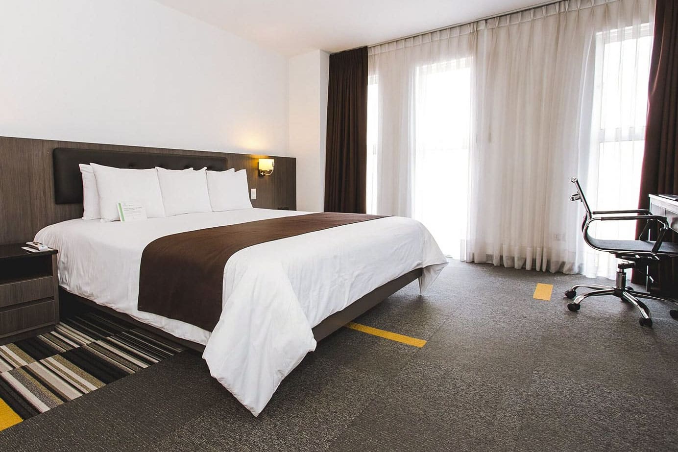
Wyndham Costa Del Sol Lima Airport Hotel
Day 1 (1 night)
Very conveniently located at the Lima international airport, this hotel is just a two-minute walk across the street from the terminal, and you can wheel your bags (no need to take a taxi). Rooms are well appointed and comfortable.
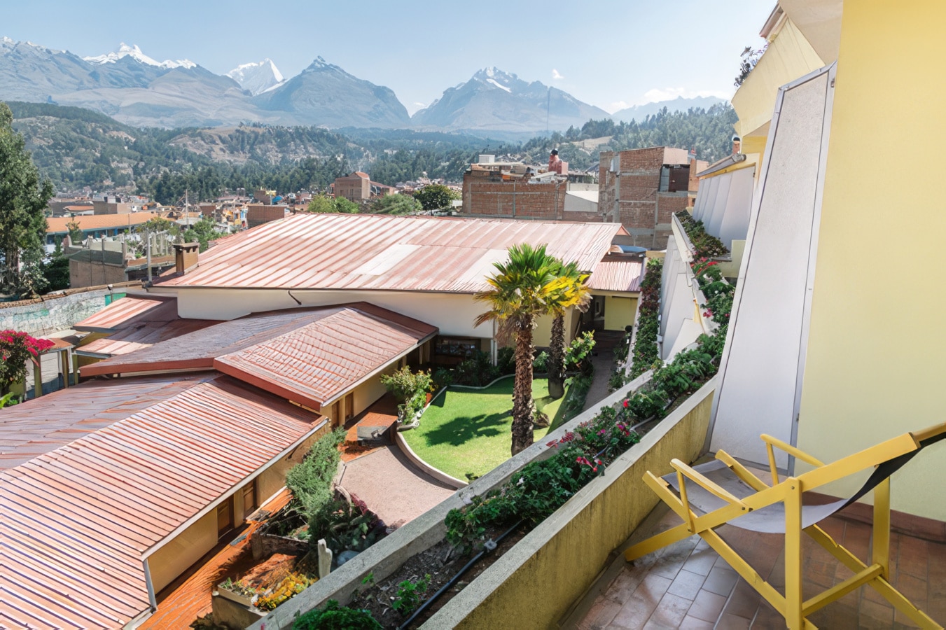
Hotel Club Andino
Huaraz, Peru
Days 2-4 (3 nights)
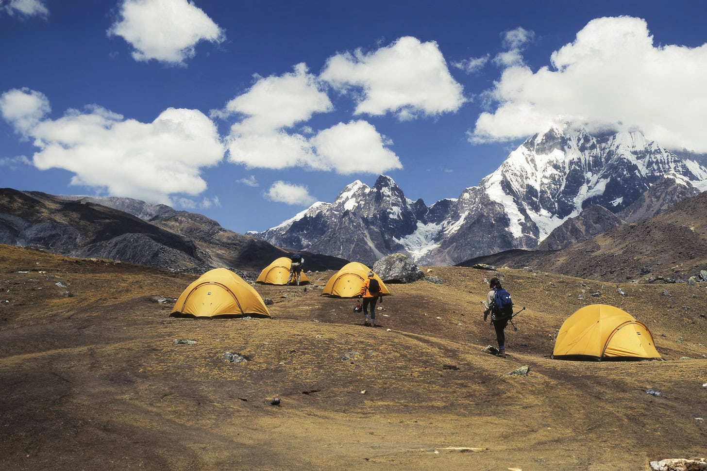
Cordillera Blanca Trek Camps
Cordillera Blanca, Peru
Days 5-13 (9 nights)
Day 14 (1 night)
Day 15 (1 night)
Trip Leaders
Wilderness Travel Trip Leaders have a passion and a joy for creating an unforgettable journey. We are extremely proud of them and the incredible travel experiences they make possible. For more information, including client comments about them and which specific trips they will be leading, please click on their profiles below.
Holly Wissler
What the Trip is Like
This trip is rated Level 6, Very Strenuous, according to our trip grading system. It is expected that each participant be in excellent health and physical condition.
- 2,000-2,500 feet gain/loss
- Altitudes range from 10,000 to 15,000 feet
- Day 6: approximately 9 hours, 2,500 feet gain/2,480 feet loss
- Day 9: approximately 8 hours, 2,270 feet gain/1,510 feet loss
- You need to be able to hike on uneven surfaces on mountain trails at high elevations. You must feel comfortable and confident on your feet for up to 8 hours a day, with recent experience hiking at least 8 miles in a day (preferably at high altitude).
A Typical Trekking Day
On a typical trekking day, wake-up is around 7:00 am, when a cup of hot tea or coffee and a basin of warm washing water are brought to your tent by one of the camp crew. After packing up our duffels and having breakfast, we set off on the trail while the crew strikes camp and the porters shoulder their loads. The crew passes us by midmorning to get ahead and prepare our lunch. We typically walk for three or four hours in the morning, then stop for a leisurely lunch of an hour or more at a scenic spot on the trail. After lunch, we walk for another three hours or so until we reach our next night's camp. The porters and crew pass us in mid-afternoon and usually have camp set up by the time we arrive. At camp, we have late afternoon tea (or coffee or cocoa) and snacks. Before dinner in the dining tent, there's free time to read or relax. Temperatures drop quickly as the sun drops behind the peaks, and it can get very cold at night, so have a few extra layers of clothing ready. It gets dark fairly early (around 6:30 pm). After dinner, we can chat away the evening in the dining tent or read by flashlight until bedtime.
For the most part, you can hike at your own speed. There is always a guide in the lead, usually the Trip Leader or the camp manager, who supervises the crew, and a "sweeper" who trails behind the slowest hiker to ensure that no one becomes lost on the trail. Most groups tend to spread out over the trail, taking photos, stopping to rest, and enjoying the scenery. We ask you not to hike ahead of the leader because trails are often not well-marked. If you feel breathless during a long ascent or wobbly during a long descent, by all means stop until you feel restored.
Extend Your Trip
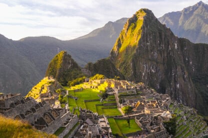
Cusco and Machu Picchu Extension
From $4,795
Client Testimonials
"This was an amazingly beautiful trip."
Buffalo, NY
"This was a beautiful trip, with outstanding hiking, magnificent vistas, and wonderful interactions with local people."
Fremont, CA
"An amazing trip! I felt the true vastness of the Cordillera Blanca through the well planned itinerary and the thoughtful and professional leadership."
"We can depend on Wilderness Travel to offer exceptional trips and great attention to detail, and the quality of the Trip Leaders is unsurpassed."
"This was one of the best organized treks I have been on. Outstanding crew and leader."
Belmont, MA
"An absolutely fantastic trip. We loved the scenery and had a really great time."
Chapel Hill, NC
"One of the best treks I have ever been on."
Wyndmoor, PA
"I think this was one of the best hiking trips I have ever taken. I loved the guides, staff, itinerary, food, and the MOUNTAINS! The scenery and weather were spectacular. This was my first trip with Wilderness Travel and I think every aspect of it was well designed and planned out, in every detail."
Woodstock, VT
"A magical tour of some of the most beautiful mountains in the world. Flawless planning and support by Wilderness Travel. Excellent trip leaders!"
Isle Of Palms, SC
Other Trips You Might Like
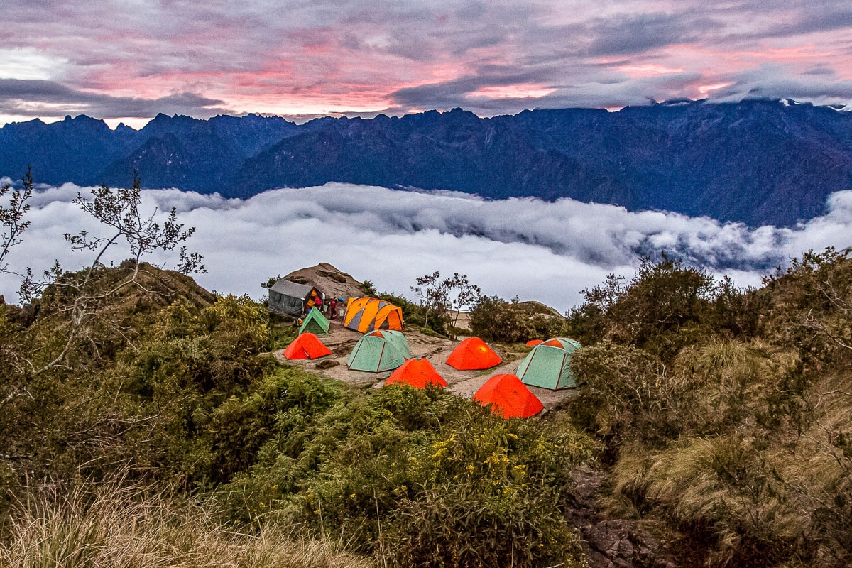
Small Group Adventure
- Inca Trail to Machu Picchu
From $5,995
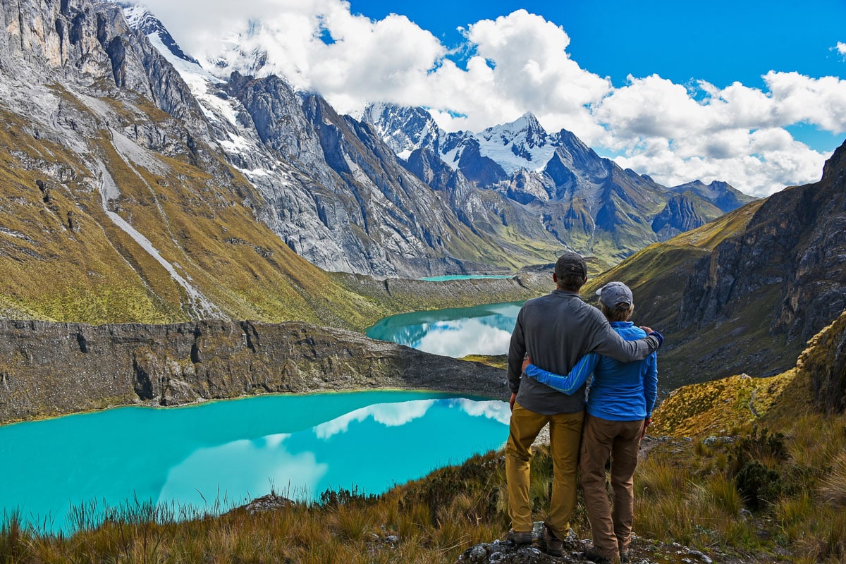
Trekking the Cordillera Huayhuash
Call for Pricing
Book your trip today
Our Area Specialists know every detail about our tours. They will be happy to answer any questions and help you choose the journey that’s right for you. Contact us to learn more or book your trip today!
Submit the form below to download itinerary
Trip Download Itin
Trip Levels
With more than 200 different adventures to choose from, we want to help you find the trip that’s right for you. Our Trip Level system ranks each trip in two ways: a number rating from 1 to 6 according to the activity, and general travel rigors. 1 is the easiest and 6+ the most difficult—see descriptions below for explanations of each number. A plus (+) sign means the trip is a bit more strenuous than other trips of that level. The detailed explanation of each trip—below the bar with the number rating—is perhaps more important, specifying activities, altitudes, hiking, and travel conditions. The Detailed Itinerary, available by download or mail, gives further information. Our Area Managers can also answer questions and guide you to the trip that best suits your interests.
Level 1 – Easiest
Non-camping journeys, optional walks, little elevation gain or loss.
- Royal Rajasthan and Villages of India
- Small ship cruises
Level 2 – Easy to Moderate
Hotel nights and/or safari-style camping, hikes of two to four hours on some days. Other physical activities are sometimes included, such as optional sea kayaking.
- Our African safaris
- Costa Rica Wildlife
Level 3 – Moderate
Half- to full-day hikes (3-6 hours) over rolling countryside on most days, occasional steep trails. Many of our hotel-based walking tours are in this category, as are our snorkeling adventures.
- Tuscany & the Cinque Terre
- Argentina: Hikes and Estancias of Patagonia
- Palau Snorkeling & Sea Kayaking
- Some trips with minimal hiking but rugged travel conditions or long drives, such as Tribal Ghana, Togo & Benin, are Trip Level 3.
Level 4 – Moderate to Strenuous
Full-day hikes (4-6 hours), mountainous terrain, significant elevation gains and losses (hiking up or down as much as 3,000 feet) on many days. Altitudes no greater than about 10,000 feet.
- Ultimate Patagonia
- Hiking the Spanish Pyrenees
Level 5 – Strenuous
Full-day hikes (4-8 hours), mountainous, steep terrain (hiking up or down as much as 3,500 feet) on many days. Trips with hiking at average altitudes of 10,000 to 12,000 feet are in this category.
- Everest Lodge to Lodge
Level 6 – Very Strenuous
Full-day hikes (5-8 hours), mountainous, steep terrain (hiking up or down as much as 3,500 feet) on many days. Most hikes take place at altitudes above 10,000 feet, with some days ascending as high as 18,000 feet.
- Everest Base Camp
- Climb Kilimanjaro!
Santa Cruz trek
It is one of the best-known trekking trails in the Cordillera Blanca and the Andes of Peru, it is located in the northern part of the Cordillera Blanca; the circuit includes the route of three valleys: Santa Cruz, Huaripampa and Llanganuco, precisely the name of the trekking circuit comes of first of them; likewise it crosses two passes above 4700m, during the trek always observe snow-covered peaks most of them exceed 5000m, and most them are the important peaks of Peru such as: Huascarán, Huandoy, Alpamayo (south face ), Tocllaraju, etc, likewise we see lakes of glacial formation of very striking colors: turquoise, dark green and light blue; a very varied and exotic flora that grow up to 4800m, great diversity of fauna, especially birds that are observed in the lakes and surroundings. The camps are set up below the mountains, on the banks of the streams, making the views of the sunset in the mountains even more interesting; the trails are quite wide, they are the same used by the pack animals (donkeys / horses and llamas), without a doubt it is one of the best options to observe the most important of the Peruvian Andes in a few days.

The best season to make this trek is almost all the year, but it is better to make during the Andean summer (April - September). Read more
Clothing and accessories
See the list of recommend gear and equipment list
Description of the trek
The trek is considered as a moderate difficulty, with 3 nights camping in places higher than 3800m, with an average walking per day of 5 to 6 hours, its highest point is Punta Unión 4750m. We strongly recommend to make at least one day acclimatization in places higher to 3800m (short hiking), previous to depart for this trek. If you have more days and you are interested to make some mountaineering activity you can extend the tour to Pisco mountain 5750m , with three additional days you can make the Santa Cruz trek and climb to Pisco mountain.
Trekking permit
The entrance tickets must be bought in advance in Huaraz, in Huascarán National Park 's office, or in the ranger station located in Cashapampa village (start point of the trek), it costs S/. 60.00 (around USD 19.00), for 2022 season.
Temperature
During the best trekking season: Mid-April to September, are dry months; the most of the days are sunny, during the day the average temperature is 14 °C and in the nights it drops until 0 °C and in extreme we expect temperature of -5 °C.
The trek is safe for the permanent presence of visitors, there have been few cases of theft.
Recommended reading
Lonely Planet Trekking in the Central Andes
Peru and Bolivia; The Bradt trekking guide
Note: All the information contained in these pages is intended for guidance only.

Day 1: Huaraz – Cashapampa – Llamacorral
At indicated time pick up in the hotel and we drive to Cashapampa village located at 2900m/ 9 514 ft, getting there take around 3.5 hours; Cashapampa village is the starting point of the trek, place where the Horseman and his pack animals wait for us; from this village we walk up through Santa Cruz valley, the trail follow close to the river among typical Andean trees, after to walk 5 hours we get to Llamacorral campsite 3760m / 12 335 ft, all the time from this place we can see Taulliraju mountain.
Day 2: Llamacorral – Taullipampa
Around 8:00 Am, after the breakfast we start the trekking, this time similar to the previous day we will continue through Santa Cruz valley on the way we visit lakes such as Ichiq cocha and Hatun cocha, (For English: small and big lakes respectively); we see snow-covered peaks like: Caraz, Aguja and Taulliraju, also we observe the Andean flora of this part of the mountain range; we get to Taullipampa 4250 m / 13944 ft, after to walk 4.5 hours approximately, place where we will set up our campsite.
Optional: One one hour close to the campsite we can take a trail to the base camp of Alpamayo mountain, on the way there is viewpoint from there we see the South Face of Alpamayo mountain and Artesonraju peak; after the break we continue to Taullipampa, all this extra visit takes around 2 hours more.
Day 3: Taullipampa – Punta Union pass – Huaripampa valley
We consider that this day is the most difficult, we go up to Punta Union 4750m / 15584 ft, the highest point of the circuit that we cross walking, place where we get after to walk 3 hours approximately; from this pass we can see very close Taulliraju mountain and others located around it, mountains like: Rinrihirka, Paria, Chacrarjaru, etc. After to take a small break and taken the photos we go down to Huaripampa valley 3850m / 12631 ft, most of the trail of this day follow a rocky path; from the pass to our campsite takes around 3 hours more.
Day 4: Huaripampa – Vaqueria – Huaraz
Around 8:00 Am, we start the last day trek, we walk down for around 1.5 hours in Huaripampa valley; then we walk up to Vaqueria village located at 3700m / 12139 ft, this village is the last point of the trek, we get there 2 hours walking; also here a vehicle will wait for us to take us back to Huaraz city; on the way we will stop in Portachuelo pass 4760m / 15 617 ft, from this pass we see the most important peaks of the Cordillera Blanca, peaks like: Chacraraju, Pisco, Huandoy, Chopicalqui and the Peruvian Andes highest peak Huascaran 6768m / 22204 ft; from the pass we go down to the valley and we visit Llanganuco lakes, Orqon cocha and Chinan cocha (for English: male and female lakes respectively), in the afternoon after driving 5 hours we arrive in Huaraz.

Santa Cruz trek map
- Altitude profile

Elevation along Santa Cruz trek
- Photo gallery

Plan your trip with local specialists
- Get started
- Trekking map
- Season 2024
Find your perfect trip:
- Gather friends and you travel for free!
- Looking for partners?
- Traveling with family ?
- +51 / 0 43 421864
- +51 943077736
- [email protected]
Cordillera Blanca Trekking & Hiking

Cordillera Blanca Alpamayo Trek – Cullicocha Lake
The Cordillera Blanca (“White Mountain Range”) is the world’s highest tropical mountain range. The name is a true testament to the range of almost countless snow-capped peaks, many of which are visible from Huaraz.
It is a compact range being 180 kilometres long and only 20 kms wide covering 340,000 hectares, but within this relatively small area there are 35 snow covered peaks that are above 5,700 meters and another 27 that soar over 6,000 meters above sea level. The highest is Huascaran at 6,768 meters and there is also the spectacular pyramid of Alpamayo, voted in many publications to be the most beautiful mountain in the world. The snow-covered peaks, the numerous glaciers and glacial lakes, the high plateaus intersected by deep ravines with torrential creeks and the variety of vegetation types form a spectacular landscape of rare beauty. In 1985 Huascarán National Park was designated a UNESCO World Heritage Site in recognition of the exceptional natural beauty, diverse & unique flora and fauna, biodiversity and archaeological values contained within the area

Huascaran National Park – Cordillera Blanca
There are countless trekking and hiking trails passing through beautiful valleys with lakes and impressive waterfalls and vertical rock faces, and crossing passes that reach up to 4850m in altitude.
We have many trek options from 3 to 13 days which transverse through the valleys and ranges of the Cordillera Blanca, offering some of the most varied and spectacular trekking scenery of anywhere in the world.
Among the many Cordillera Blanca trekking options is the famous 4 or 5 day Santa Cruz Llanganuco trek , one of the most highly rated short treks anywhere in the world.
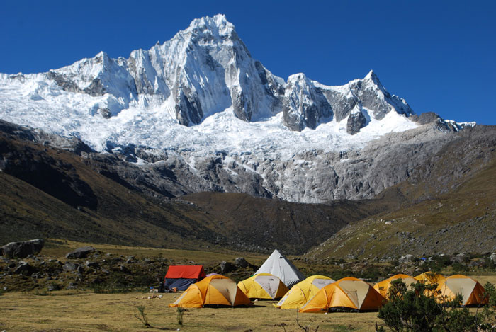
Or are you looking for a remote Peru trekking & hiking experience, away from the busier trails and tourist “hot spots”? Check our Olleros to Chavin trek (3 days) with Llama & Horse trek options and Olleros to Carhuascancha and Chavin Trek (6 days) – Llama trek option
TREKS These are just some of the Cordillera Blanca Trek options. We are very happy to discuss with you what you would like to do or see, the amount of time you have and can modify trek itineraries or “tailor make” a trek route to suit what you would like to do.
CLIC on the treks listed below for descriptions:

GENERAL CORDILLERA BLANCA TREK INFORMATION
Trek Grading & Fitness Trek grading and walking times are average estimates only for people of average fitness and who are well acclimatised to the altitude. Some people will be much faster and others will find it more difficult and be much slower. Estimated times have been based on our experience with previous groups. Your own hiking speeds will depend on how well you have adjusted to the altitude as well as your own personal fitness level. The effects of altitude do make the hiking much harder than a similar trek closer to sea level would be and different people adjust to the altitude in a different timeframe.
You need to have average to good fitness and be able to hike a sustained uphill climb for 2 to 3 hours without distress and manage the long descents down from the passes to be able to enjoy these treks, and also be able to manage several nights sleeping in tents in sometimes very cold conditions.
Easy / Moderate Trek: have some almost flat & easier walking mixed with moderate steepness hill hiking or climbing to the top of a mountain pass that is less strenuous than some of the other pass climbs
Moderate Trek: Will have a sustained climb to at least one high mountain pass (up to 4800m) with a corresponding steeper descent back down, mixed with some valley hiking. There can be some longer days (around 6 hours hiking) mixed with short days
Hard Trek: Some treks are considered to be Hard, generally because there are some long hiking days on trek. There will be multiple high mountain passes to cross (up to 4800m), with some treks having a high pass almost every day on trek. Routes can be less utilised so can be in rougher condition that some easier trek options. You should have above average fitness for these treks, good endurance and be able to hike for a long day 8 to 10 hours (taking your time and enjoying the views)
Note: that most trekking options in the Cordillera Blanca should be considered to be physically demanding owing to the altitude (you are above 4000m for the duration of the treks) and the mountainous nature of the terrain. Trails are often steep – both ascending or descending. Trails are not formed walking paths and can be uneven, slippery & rocky in places. It is a common comment from clients that they found the hiking to be harder than they were expecting.
This is usually due to the effects of altitude which invariably leaves people feeling less energetic than they would on similar hikes at lower altitudes. If you do not think you can enjoy this type of trekking, let us know and we can suggest some easier options
During treks we use donkeys to carry camping & cooking equipment, tents, food and your personal bag. You only carry a light day pack with camera, snacks, water bottle, warm jacket etc.
Our guides and crew are very experienced and know how to manage trekking at altitude. We always walk slowly, take plenty of rest breaks and make sure that you have plenty of boiled water to drink.
See our SERVICES page for a full description of services that we offer.
Altitude and Acclimatisation: Before departing for your Cordillera Blanca trek it is important to be well acclimatised to avoid possible altitude related illness.
Altitude symptoms vary but can include headache, nausea or vomiting, breathlessness, lack of appetite, stomach problems, extreme lethargy and lack of energy, inability to sleep – from mild to severe in extent. In extreme cases pulmonary or cerebral oedema are possible
We do highly recommend that you arrive in Huaraz at least 2 full days (3 nights) before the trek departs to help you become acclimatised to the altitude. It is advisable to have two full days in Huaraz to recover from your travel and do day hikes to higher altitude to help with acclimatisation before departing for the trek.
We can advise on suitable acclimatisation hikes and either organise guided day hikes for you or you can choose to do your own unguided hikes and we can help with transport
See our Day Hikes in the Cordillera Blanca page for options
Trek Roads Access to and from all Cordillera Blanca treks is via high mountain roads. These roads are mostly dirt roads (not paved).
Best Time to Go May to September are considered to be the months with more settled weather and better chance to have nice hiking weather.
June, July & August are generally the dryer months in the Peruvian Andes but are also the busiest trekking months. May and September are “shoulder” months with some good trekking weather still possible and usually fewer other trekkers on the trails.
May is at the end of the rainy season and spring conditions with spring rain showers still possible, the weather is often improving with often clear skies, everything is fresh and green following the rains and there are lots of wild flowers. September is at the end of the “dry” season and approaching the start of the rainy season, there can still be periods of good weather for trekking and it can be more relaxing with fewer large groups around.
Other Trekking Information: see our MENU-Trek Services & Booking pages for a full description of services that we offer and general trek & climb information.
Cordillera Blanca vs Cordillera Huayhuash
We are often asked what is the difference between the two regions or which is better for trekking in. Both areas are very spectacular but different and it is impossible to compare them. Both have amazing snow capped mountains and glaciers that you hike by very close to & both have continuous breath taking hikes up to high passes with incredible views on most days of the treks.
The Cordillera Blanca valleys are steep sided and more narrow – often with massive glacial carved granite rock walls lining the valleys. Each valley you cross into has a unique microclimate with a different look, often different plants & flowers. Some areas are forested with low forest and other areas are more open valleys with grasslands. There is more diversity of plants, flowers and trees in the Cordillera Blanca than the Huayhuash. More local people live around the Cordillera Blanca and there are more villages and small farms on the areas bordering the National Park. You will meet more local people on some Blanca treks than in the Huayhuash. Apart from some of the more remote trek options – there generally can be closer road access to the trek circuits in the Cordillera Blanca than in the Huayhuash which can make it easier to organise departure from the trek route if necessary. Driving time between Huaraz and most Cordillera Blanca treks is less than in the Huayhuash, and you are therefore able to start hiking on the first day of the trek program after driving to the trek start point in the morning.

Alpamayo Circuit – Cordillera Blanca
The Cordillera Huayhuash is more open with wide valleys and expansive open grasslands. There is less diversity of plants and trees, although you still do find pretty wild flowers in most places and there are scattered areas of high altitude quenual trees. There are more big lakes in the Huayhuash & many of them contain trout. Many of the campsites are by a lake. There are fewer local people living around the trek circuit than you may find on some Cordillera Blanca routes, just some small farms and a few homes scattered around the lakes. The only villages are Llamac at the start of the trek (where our donkey drivers live) and a couple of other villages close to the trek circuit. Travel time to the Huayhuash is greater with minimum 5 hours journey to the start of the trek then back to Huaraz after the trek finishes. Generally in Cordillera Huayhuash treks the first day of the trek program is driving from Huaraz to the start point of the trek and camping there the night, with hiking starting the next morning.

Laguna Jahuacocha Cordillera Huayhuash
Contact us for information & your questions about a Cordillera Blanca Trekking Adventure
CORDILLERA BLANCA NORTH & SOUTH MAPS


Dates & Prices
Activity level, accommodations, peru cordillera blanca trekking tour, trek among the white mountains in a stunning glacial wilderness.
Experience the extraordinary beauty of Peru's Cordillera Blanca on this high-altitude trek for experienced hikers. The stunning Cordillera Blanca is the highest tropical mountain range in the world, with 27 peaks over 19,000 feet, linked by isolated valleys. Hike through a glacial wilderness of translucent turquoise lakes, hidden waterfalls, and striking pinnacles, and keep an eye out for vicunas and soaring condors. Drink in vistas of sharply ridged peaks, including the remarkable "perfect" pyramid of Alpamayo. Challenging? Yes, but a fantastic, bucket-list triumph for those who choose to undertake it.
From: $4,995
- Available: May, June, July, August
- Activity: Level 5
- Accommodations: Comfortable Camping, Comfortable Hotels
- --> --> Group Size: --> -->