Where Your Travel Memories Come to Life

The Better Way to Share Your Travel Memories
Wow your friends with an animated travel map .
Check out one of our animated travel maps created with PictraMap®!
Why is this the tool that you've been waiting for ...
No credit card required, create your first animated travel map within minutes.
It's different
WOW your friends and get them talking about you and your travels.
It's all you want
Free online tool to create animated maps from travel photos. Ain't that right?
No wait time
The tool is entirely web-based - you register and get instant access to the system. Create your first animated travel map within minutes!
Beautiful maps
It is not yet another tool with Google maps, offering the same old same old map layout. Find the map that matches your taste and type of trip.
Customization
No other online tool offers so many customization options - you choose the map, pins, intro, ending, music theme, not to mention the color options.
Easy to use
You don't need any tutorial because of the super-easy interface - register and within minutes, you can have your first animated travel map.
Easy to share
Because it's all online, you can always share your animated travel maps with the world - on Facebook, via email, even embed it on your blog.
It just is ...
Passionate travelers badly needed such a tool (we know, they told us so). Be among the first to create an animated travel map with PictraMap®!
Are you ready to be a pioneer? Dare to be different?
What passionate travelers say about pictramap®.

I was pleasantly surprised of what I saw when a friend shared the link to PictraMap. The unique way I can create and share my albums there lets my friends and family enjoy the fun moments of my trips. I like the flexibility and variety of the maps, the transitions between locations, and the music scores I can choose from – all in a very quick and intuitive way. Thank you, guys!

What a great way to give life to my countless otherwise boring photos! The maps, the music, the colors make every album special and help add an emotion to it. It's easy to use and the result is a fun adventure I could share with all my friends and family! I know they will love it too!!
Busy? No problem - we'll remind you!
If you're too busy to create your first animated travel map right now, or you think your friends can wait being WOW-ed by your last amazing trip, join our community. We'll remind you later that your travel photos can still get the attention they deserve 😉
Browse Site
- Start Here!
- Plans & Pricing
- Log in to PictraMap
- Create an account
From The Blog
- Convert PictraMap Animations to Videos: Built-in Feature Released
- Search by GPS Coordinates, Full HD Pics and New Maps Released
- New Customization Options Now Available in the ‘Extras’ Tab
Get in Touch
Want updates via email.
Animated travel infographics
Zero-config animated maps
Visualize your journey with beautiful animated maps. Perfect for adventurers, travelers, and explorers wanting to showcase their routes and destinations.
Johnatan Cook
Hey mate, this site is awesome! As a s/w product mgr myself, this is very well-done! I was googling for something exactly like this for a while, I've used relive.cc for cycling before but it doesn't support non-sports activities.
David Osterholt
For years I've been looking for something this simple. I've been doing it i powerpoint and it takes forever to do something that looks presentable. This is really great.
Superb Quality and great animation, maybe it would be nice to have more parameters to play with during the animation. Will recommend though to other doing trips to create awesome content ! Thanks to the support as well from the team it was incredibly helpful for my case
Animated Maps
Start creating your animated maps for FREE and enjoy a 25% discount on our commercial GEOLayers.app plans for early birds.
Become an Early Adopter
Create stunning animated maps direcly in your Browser!
Design, Create, Animate and Share Maps - All in one place! GEOlayers.app lets you create animated maps in a breeze!
Unlock your imagination: effortlessly select colors, design harmonious basemaps, create outstanding labels, and more! Seamlessly animate with our item-based timeline - Say goodbye to fiddly keyframes and value graphs.
GEOlayers.app offers all the tools you need to tell your story with a map!
Try GEOLayers.app now for free!

Adjust colors, basemaps, labels and styles.
Design Maps
GEOlayers.app helps you with colors, basemaps, labels and styles to highlight features on your animated maps.
Design your first animated map

Create animated maps directly in your browser!
Create Maps
Create animated maps of any place in the world, highlight features, add Labels, place Icon Markers or even draw directly to your map. Possibilities are endless!
Create your first animated map

Item based timeline - no keyframes needed!
Animate Maps
Our item based timeline lets you create smooth animated maps and transitions in no time. It can handle automatic animations like flashing features or rotating 3D viewports while giving you all the control you need.
Animate your first map

Render presets for different use-cases availbale
Render Images and Videos of your animated maps in all formats and resolutions you need! Export the same animation as an easy to share MP4 file for social media or lossless 4K image sequence for further editing, all with one click!
Render and Share your first animated map
If you need more...
... please have a look at our Adobe After Effects Extension GEOLayers 3. It gives you even more control and creative freedom to animate maps leveraging the power of Adobe After Effects. Check it out on aescripts.com

follow us on social media
Create Memorable Animated Travel Videos
Travel Animator is your perfect travel companion, making your trips even more exciting. With our app, you can effortlessly create captivating videos to share on your social media. Take the art of storytelling to the next level by tracing your journey and transforming it into a dynamic video.
Embark on a Cinematic Journey
Have you ever wished to relive your travel memories in a way that's as thrilling as the adventure itself? Introducing Travel Animator, the premier travel software that transforms your travel memories into captivating Instagram videos. Dive into a world where every journey is a story waiting to be told.
Indiana Jones Inspired Maps
Navigate your adventures with our unique map interface, reminiscent of the iconic Indiana Jones. Watch as your route unfolds, leading you from one destination to the next, complete with animated transitions.
High-Quality Video Production
Our advanced algorithms ensure that your videos are of the highest quality, capturing the essence of your travels in cinematic brilliance.
Easy-to-Use Interface
Whether you're a tech-savvy traveler or a newbie, our user-friendly platform ensures that creating your travel video is as simple as a few clicks.
Share & Inspire
With seamless Instagram integration, share your adventures with the world and inspire others to embark on their own journeys.
What Sets Us Apart?
While other platforms, like TravelBoast, offer ways to record and reminisce about your journeys, Travel Animator takes it a step further. We don't just let you note down cities or add photos; we animate your entire experience, creating a visual masterpiece that resonates with the thrill of the journey.
I've traveled to over 50 countries, and capturing those memories has always been a challenge. With Travel Animator, not only do I get to relive my adventures, but I also get to share them in the most cinematic way possible. The Indiana Jones-themed map is the cherry on top!
Every time I use Travel Animator, I'm transported back to the winding streets of Rome, the serene beaches of Bali, and the bustling markets of Bangkok. The animated map feature makes my travels feel like a blockbuster movie. Absolutely in love.
Travel Animator is a game-changer! I used to spend hours editing my travel videos, but now, with just a few clicks, I have a masterpiece ready to share. The animated map journey adds a touch of nostalgia and adventure to every video.
As a travel blogger, I'm always on the lookout for innovative ways to showcase my journeys. Travel Animator does just that and more. The Indiana Jones-inspired map animation has my followers constantly asking how I create such captivating videos!
From the snowy peaks of the Alps to the deserts of Sahara, Travel Animator has been my trusty companion. The quality of videos and the ease of use are unmatched. Plus, the animated map adds a whimsical touch that my audience adores.
Ready to Begin Your Cinematic Adventure?
Join the community of travelers who've chosen Travel Animator to immortalize their adventures. Let's turn your travel memories into cinematic gold.
Travel Animator - Where Every Journey Becomes a Blockbuster.
© Travel Animator - 2023
Map My Travels
Create an Interactive Travel Map of Your Tours and Activities
Are you dreaming of creating your own interactive travel map to bring your tours and adventures to life? With Map My Travels, it's easy! Craft and share custom maps of your travels, embedding them seamlessly on your website. Start mapping your journeys and share them with the world today!
Creating a travel map has never been easier
Combine an intuitive travel map creator with many customization options like uploading your own marker icons as well as loading in GPS files. Creating an interactive travel map has never been easier.
Create custom markers
One of the key features of Map My Travels is to customize the way you want to show waypoints on your travel map. That's why you can add markers to your map in multiple ways:

Add content to your travel map
A map marker without information is not a good marker! People want to know what happened at that specific place. That's why you can easily add a popup to your markers and routes, where you can add the following pieces of content:
Fill your travel map with content!

Embed the travel map on your own website
You can share your map in many different ways. You can share a link to the map on social media or where ever you like. You can also embed the map on your own website, like I've done on my personal website! It doesn't matter if your website is made with Wordpress, Squarespace or any other.

Upload GPS files
Upload your recorded travel data with ease. In the Map My Travels editor you can upload GPS files in the following formats:
After you've added the GPS files you can still change the line's appearance, like color, thickness, opacity etc.

Import your Strava Activities
If you host your travel activities on Strava, a popular fitness app on which you can share your traveled routes (usually used by hikers or cyclists), you can import these directly into the map creator!

If you don't have any recorded route data like from Strava or a GPS file, you can still add lines to your map by just drawing on the map!

Change the look of your travel map
You can customize the look of your map with 4 different map types that Google Maps provides:

Create as many travel maps as you want!
You can add as many travel maps in your account as you want, completely free! There are only limits on the amount of markers and routes you can add to your maps. But you can get started for absolutely free. See more information on pricing and limits on the pricing page.

Create travel maps on any device
All of the map creator features are totally compatible with both laptops and phones. Out of personal experience, I'd recommend editing the maps on a laptop or computer. The experience is a bit better for panning around the map, but it's totally possible to do it on a phone as well. Your travel map will look beautiful either way!

Built by TravelingTice
Hi! I built this application myself as I have both a passion for coding and travel! I've cycled through 13 countries in Europe as well as part of Taiwan!
Brands creating travel maps with Map My Travels

Free animated travel map
Enhance your trip route with photos and notes.
Experience your journey like never before by adding stunning photos and personalized notes to your trip route. With our innovative feature, you have the power to create a truly immersive travel experience. But that's not all – we also offer the flexibility to customize the animation style of your photos and notes, giving your trip a unique touch of creativity. Start documenting your adventures in a visually captivating way today!

Route Animation
With roadtripplaner, a versatile travel map generator, you have the ability to personalize your route animation. Customize the color of your route to match your preferences or branding. Choose from a variety of vehicle icons to represent your mode of transportation, making your map even more engaging. Create a visually stunning and unique travel experience with our route animation feature.
Export Animated Route to Video
Once you've completed creating your travel map, roadtripplaner allows you to export it as a video. Easily share your captivating animated route with friends and loved ones. Whether it's reliving your memorable journey or showcasing your travel adventures on social media, exporting your travel map to video format ensures you can share your experiences in a dynamic and visually appealing way.

Embed Animated Travel Map to Your Site
Easily enhance your website with an animated travel map by embedding it within seconds. With roadtripplaner, you can generate a personalized travel map and then seamlessly integrate it into your website using an iframe. In just 30 seconds, you can enrich your site with an interactive visual representation of your travel adventures, captivating your visitors and adding a unique touch to your online presence.

- Google Earth
- Earth Engine
- Earth Outreach
Let the world tell your story
Earth Studio is an animation tool for Google Earth’s satellite and 3D imagery.
Inside Earth Studio
Powerful motion design, all in the browser. Earth Studio gives you the tools you need to create professional content with Google Earth imagery. Read more in the Documentation .
Keyframe Animation
Earth Studio uses keyframes, just like other industry-standard animation tools. Move the globe, set a keyframe, rinse and repeat. It’s that easy.
Quick-Start Projects
Create an orbit, or fly from point to point. Select from up to five templates to get started - no animation experience needed.
Animatable Effects
Animate custom attributes such as the sun's position, the camera's field of view and more.
3D Camera Export
Easily add map labels and pins in post production. Earth Studio supports camera export to Adobe After Effects.
Try the Earth Studio preview
Earth Studio is free to use and works with the desktop version of Google Chrome. Sign in with your Google account to request access. Learn more
Earth Studio works with the desktop version of Google Chrome. Sign in with your Google account to request access. Learn more .

You'll never travel without our trip planner again
Travel planning at its best. build, organize, and map your custom itineraries in a free travel app designed for vacations & road trips, powered by our trip planner ai.

Your itinerary and your map in one view
No more switching between different apps, tabs, and tools to keep track of your travel plans.
Features to replace all your other tools
Add places from guides with 1 click, collaborate with friends in real time, import flight and hotel reservations, expense tracking and splitting, checklists for anything, get personalized suggestions, plan like a pro.
Unlock premium features like offline access, unlimited attachments, flight deals, export to Google maps, and much more
Offline access
Unlimited attachments, optimize your route.
4.9 on App Store, 4.7 on Google Play
Discover your next favorite destination
Have tips of your own? Write a guide to share with other travelers like you!
Ready to plan your trip in half the time?
For every kind of trip and every destination, the best road trip planner, the best vacation planner, the best group itinerary planner.
Trace your travel itinerary on an interactive map
For past, present and future trips. Attach photos, videos and articles to your map. Share it with a simple link.
A modern travel blog centered on a map
Easy for you to manage. Easy for your family and friends to follow.
Your own website
Create a free account to store all your maps.
Share the link with anyone you want. They don't need an account to follow you.
You can protect your blog with a password to make it private.
A map on your homepage
The best way for visitors to visualize your trip is the itinerary, show them:
- where you are
- where you've been
- where you're going
- the transport modes you used
Content comes next
Once you added your spots, you can attach content to them:
Personalized maps
Use the map editor to add your points, trace your lines or import GPS files.
Choose the map style, the marker icons and the line colors (defined by your transport modes).
No technical knowledge required.
Works on any device
Most travelers update their blogs on their smartphone or tablet.
You don't need to install any app. Just open the link to your blog or administration.
Automatic / real-time updates
You can synchronize compatible smartphone tracking apps with your map to update it automatically.
For remote adventures across oceans or deserts, you can synchronize satellite GPS trackers .
Embed your map
If you already have a website, you can embed your map on any page.
Compatible with WordPress, Wix, Squarespace, etc.
Print a photo book
Generate a travel book in one click from the content you already have to keep a tangible souvenir.
You can also download the PDF version to keep a digital copy.
Free for basic features, pay for extra
I don't display ads nor sell your data. So advanced features require a Premium account to keep TravelMap viable.
Stop paying when you don't travel. Keep all your content.
Ideal for long distance trips
Used by 150 000 travelers . Find inspiration from existing itineraries.
Built by Clément Mas. Solo-founder who cycled around Australia and rowed across the Atlantic ocean . Also a web developer.
Striving for a simple, clean and clear interface
Create your travel blog in 2 minutes.
MapFling: easily share free maps with your own custom markers!
Mark custom points on map with your own annotation or description, share the map with others by email, instant messaging, blog, websites, party invitations, wedding, events, evites, corporate hospitality and hotel and restaurant travel: welcome business customers and interview candidates to office visits, meeting maps for appointments, meeting your friend, online date, boyfriend, or girlfriend, real estate, house rentals, apartments for rent, properties for sale, collaborate on maps for travel plans, scavenger hunts, real estate.
How to make an animated travel map?
How to Make Travel Map Animation Step by Step

Had a wonderful trip and now want to recap your travel memories and share them with your friends, family, and subscribers? Or, perhaps, you want to map out all the locations you plan to visit during your upcoming journey? Whatever the case, there is a creative solution to put your vacation photos to use - create an animated travel map!
In this article, we’ll show you how to make travel map animation on your PC using a convenient slideshow maker. Also, you will watch a sample video for inspiration. Finally, you’ll learn alternative ways of creating travel animations to map out your remarkable journeys.
The first software we’re going to use to create a travel animation video is SmartSHOW 3D. It’s equipped with a special Travel Map effect suite that helps create interactive maps with photos from every location. Also, the program helps add voice comments and accompany your video with music. Besides, it offers 700+ effects and slideshow templates to make a memorable animation video. SmartSHOW 3D comes with a free trial, so you can check whether it’s suitable for you paying nothing. Let’s see what the program offers you in terms of travel map animation!
Step 1. Download and Run the Program
First, install SmartSHOW 3D on your computer. Click the button below and start your free trial.
Step 2. Create Your Travel Project
Once you open the program, click New Project. Switch to the Effect tab and in the Motion section, pick the Travel Map animation effect. Hit Create Map in the preview window to design your trip project. In the inclusive library of this animated maps software, you will discover a lot of stylish map designs - from retro pirate to modern illustrated. If you don’t find the map of the location you need, you can look it up on the Internet and upload it into the program. What’s more, you can resize the chosen map if you want a closeup of a particular place on it.

Step 3. Draw Your Route
Now it’s time to create the route of your trip. Think about the places you have visited and double-click on the locations to add map markers in the corresponding order. You can add as many of them as you want. Hit Next to move on to map customization.

Step 4. Create Your Animated Travel Map
At this stage, you’re going to work on animation. Select map markers individually and clip the corresponding photos from your trip to them. Adjust the Animation settings for each of the destination points to provide the viewer with sufficient time to observe your photos. Choose the marker image that suits the map style. Hit Next and select the vehicle and the route images. Hit Done to generate your travel animation.

Step 5. Review Your Animation and Edit It
Click the Play button on the preview window to watch your travel map video. If you want to make adjustments, click the Edit Slide button and double-click the Travel Map layer. Here you can work on your animated map further - for instance, rescale the animated elements of the map. Want to make your video more interactive? Use the Sounds tab of the Edit Slide menu to accompany your map with music from the built-in library of 250+ royalty-free soundtracks of the animated map creator. Alternatively, upload a tune from your PC.

Step 6. Save Your Travel Map
When you’re done with the editing process, export your animated travel map for a video project or use it solely. Just click the Create Video button in the upper right corner of your play screen. The program has over 15 export options to choose from, whether you are planning to watch your animation on a smartphone, PC, or a bigger screen.

It takes just a few clicks and your imagination to make a fascinating animation of your trip with SmartSHOW 3D. Prefer watching videos for learning new techniques? Check out our video guide on how to make an animated travel map with little effort and see what results you can achieve.

Looks cool, doesn’t it? Just imagine, you can create similar animated maps and it won’t take you hours of work. Just pack your photos and a joyful mood and put together all your travel memories with SmartSHOW 3D. Why not start now? Just click the button below and get a free trial version.
Now you can recap your travel memories and make your own travel map with ease!
Create Travel Map Animation: 3 Alternative Ways
SmartSHOW 3D is suitable for users of any skill level in slideshow making. If for some reason it’s not what you’re looking for, or the software is not compatible with your device, we’ve prepared 3 alternative animated map makers worthy of your attention.
Whether you don’t want to download extra programs, Travellerspoint will be a brilliant solution. This web-based app allows you to add photos and dates to each location on the map and shows how many kilometers you’ve traveled from destination to destination. But you have to become a supporting member to save your maps as PNGs and block ads within the editor. In the free plan, you’ll only be able to map out your journey.
If you’re looking for more options available for free, then PictraMap is the right choice. This is an online tool that helps make detailed animated road maps. It offers diverse customization options: music themes, pins, and maps. However, unless you buy a subscription, you can add only 10 locations and make only 2 projects inside this editor. Still, you can change the map style and the marker images for free.

Prefer using your smartphone to create travel content? There is an interactive travel map animation creator for you - Tripline . This app is available for both Apple and Android smartphones and has simple yet efficient features to draw routes of your trips. With this editor, you can add your photos to every destination marker and make your map more interactive. Then, you can easily share your memorable travel animation online. But this app is not as inclusive - you can’t change the marker and map designs. It’s suitable for planning your next trips or making minimalistic Insta stories rather than creating travel movies for big projects.
Now you know how to make an animated travel map in 4 different ways and can design your own in a couple of clicks. There are various online options that can help you share your travel memories. But if you want the process to be fun and easy, consider SmartSHOW 3D. This program is packed with dedicated tools and features to help you create live images, make exciting presentations, and design animated slideshows with photos. So building your new traveling animation and completing many other tasks related to producing slideshows and videos won’t take much time and effort if you use this software.


Build a free custom map in seconds.

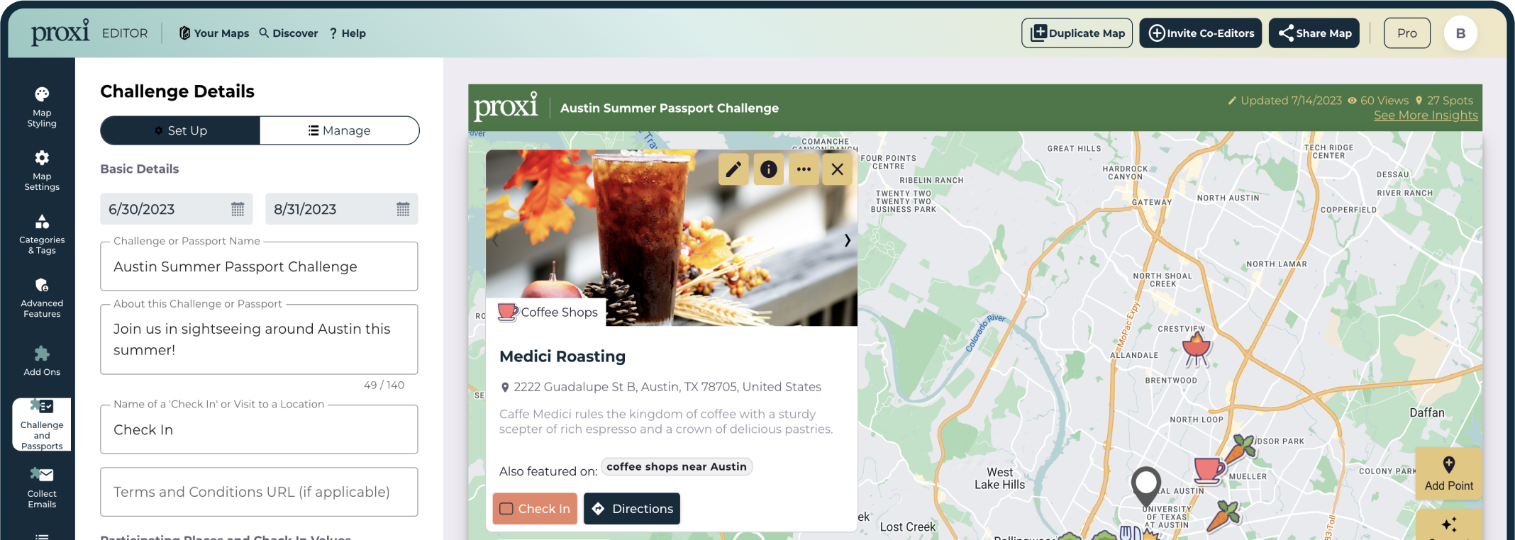
Build a custom Map for your Audience
Use proxi to share recommendations, curate local guides or visualize data for personal and business needs. no experience needed, map historical places from, places to host a work event with this vibe:, paste a list of places here and we will plot them for you on a map:, center your map here:, create a digital push pin map of your places, branded map widgets that engage, generate leads and increase revenue. no experience needed..

Embed the map widget anywhere and get game-changing analytics.
We didn't reinvent the wheel, just the map., see how others are mapping with proxi.

Search and save places to your map without leaving Proxi for Google, Yelp, or blog posts.
Seamlessly search for types of places and save locations to your map directly within the Proxi editor. Search empowers you to find the right places, right here, right now.

Proxi Passport Challenge
Increase foot traffic in your community with a digital alternative to a traditional stamped passport booklet.
Generate leads with your map
Capture and engage with your valuable and active audience from within your Proxi Map. Create a custom pop-up form that will prompt your map viewers for their details, and watch your subscriber list grow.

Ensure your map content fits in your marketing assets
Add map title and subtitle, set map center and zoom level, and customize your map background. Brand maps with logo and header color.
Future & historical events + itineraries
Transform your map-making experience by integrating date and time into your maps. Create interactive journeys and events that resonate with your audience, making your maps more than just a visual tool.

Unlock powerful insights into your audience's behavior.
Discover valuable metrics on your viewership and engagement. Download and share these powerful metrics with your key stakeholders.

Changing the game for teams of all sizes
Erica Lindemann
Director of Marketing
Visit Vancouver

Anthony and Marlie Love
Travel Influencers
Traveling While Black in Seattle

Denver Based Influencer

Colton Davis
Senior Manager - Marketing
Ballard Alliance

Charlie Sprinkman
Everywhere is Queer

Larry Hoffman
Food Critic
Dine Sarasota

Ready-to-Build Map Templates

Adventure Awaits!
How would you like to plot your course!?
Endless Ways to use Proxi
Proxi is used by thousands of creators every month to make maps for any niche or need..

Tasting Rooms and Vineyards

Austin Restaurant Week 2022

Serial Podcast Map

Speaking of Crime Podcast

Victoria - Dog Friendly Girls Trip

Road Dog Travels

Dog-friendly Travel: Seattle

Dog Friendly Places

The Big Island

London Dark Tourist

Witch Businesses in BC

Fisherman's Village Music Festival

Highway 395 Road Trip Stops

Dog Friendly Hikes Salt Lake

Your Heroes Across America

Eisenbeis Wedding Weekend Map

Great hikes near Raleigh, NC
Fun and Fabulous Fredericksburg

Tulip Farms in Oklahoma

Tulum's Most Instagrammable Spots

Cold treats in Austin, TX

New York City Instagram Guide

MYKONOS INSTAGRAM SPOTS

AMALFI COAST INSTAGRAM SPOTS

Best Edinburgh Mini Golf Spots!

Disc golf courses

4th of July Festivals in Texas

U District Cherry Blossom Festival
Seattle Boba Fest

Wineries In Dripping and Driftwood

Toronto Skaing Rinks

Best Spas in Austin

Clark County, WA Wineries

Worldwide Queer Owned Business Map
Best Bars in Denverfdsfs
✔ event maps, ✔ analytics, ✔ team accounts, proxi is changing the game for teams of all sizes.
We will continue using Proxi for a really long time because it is so easy to update, put on our website and use in different ways.
It is super easy to build and maintain maps in Proxi...using Proxi made us feel like we were professionals... creating a new one doesn't take us much time at all.
Proxi is a one of a kind mapping tool and makes access to travel inspiration so much easier and more efficient.
The maps are super user-friendly and way better than anything Google Maps offers. The features are fantastic!
Proxi has completely changed the game for my business, in the best possible way! My map has been viewed over 1.3 million times and knowing the experience that my users are having because of Proxi makes me so happy. I can now upload 200+ points in less than 5 minutes!
I have been waiting for a map making tool like this for years. Using Proxi has made plotting my dining recommendations on an interactive map super simple. My readers love seeing places presented in a way that is easy for them to view and interact with.
Real maps, built by real people

Seattle Restaurant Week turned to Proxi to display all of the participating restaurants in Seattle Restaurant Week 2022. The map gathered over 300,000 views and the organizers were able to deliver usage analytics back to the restaurant.

GVL Today is the Greenville 6AM City Newsletter. 6AM City locations all over the U.S. Regularly include interactive Proxi Maps as part of their guides to the city. This map was a map to the Pizza options in Greenville (complete with images!)

She Matters is a digital health platform designed to provide Black mamas who experience postpartum anxiety and/or depression with community, culturally relevant resources and culturally competent therapists.
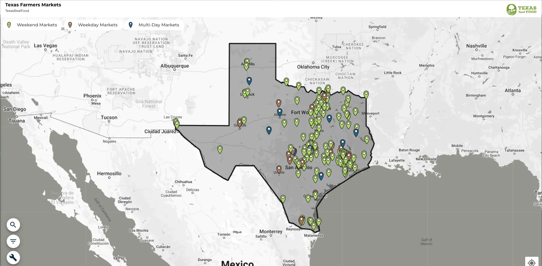
TexasRealFood is the #1 business directory and information resource for locally produced, real food in Texas. They created a map so their audience could find weekend and weekday markets throughout Texas.

The Austin Things regularly publishes helpful guides to the Austin area. Kelsey, the creator, includes Proxi Maps in her guides to make converting on her recommendations easier.
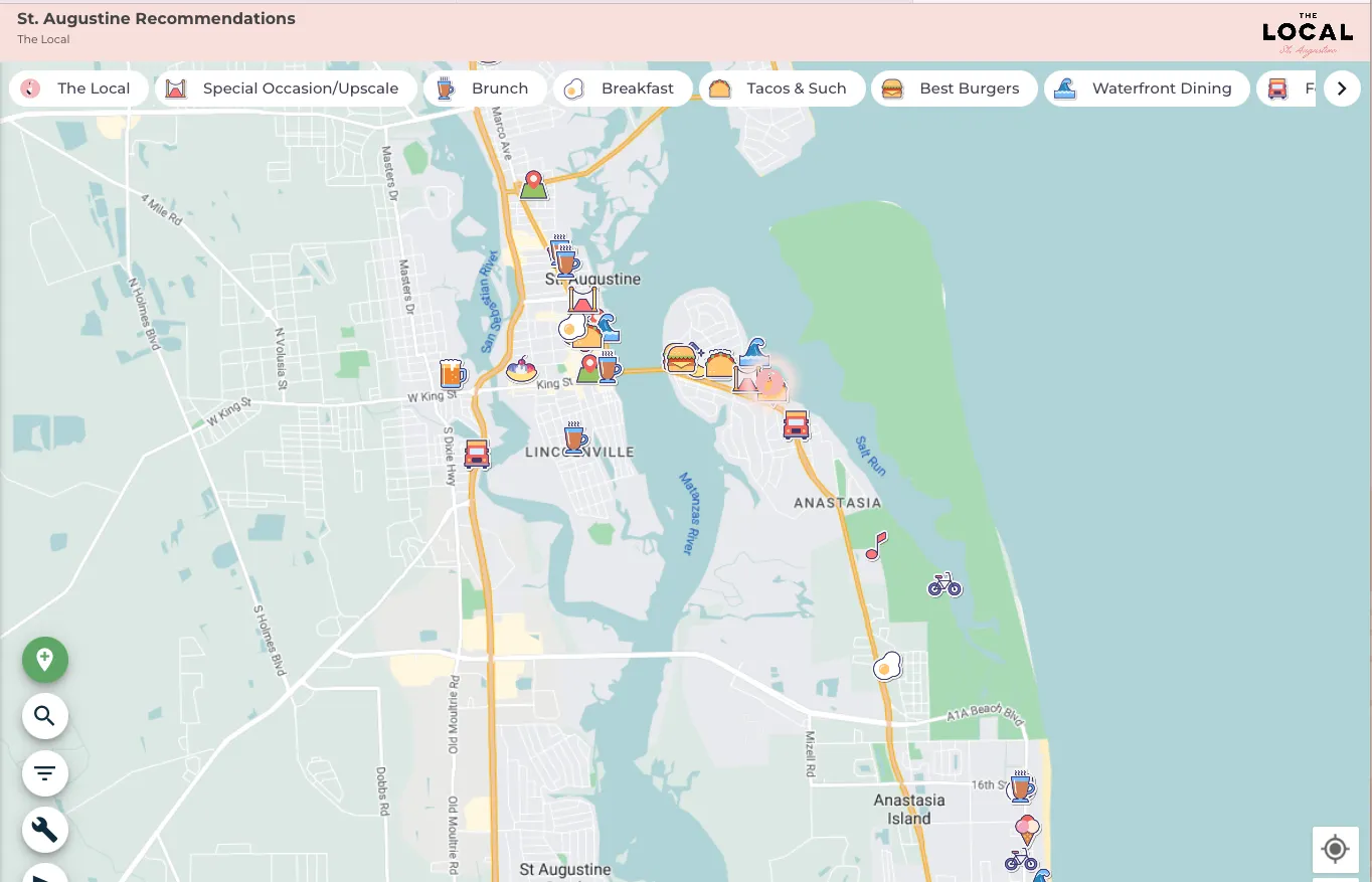
The Local is an independent inn located in St. Augustine, Florida. The property created a curated map to show off local recommendations to their guests. They provide the map in their app upon check in.

Houston Mom, Marcella, used Proxi to crowdsource formula needs and availability during the U.S. Formula Shortage. Thousands of people used the map in their time of need.
Discover our products
Lorem ipsum dolor sit amet, consectetur adipiscing elit...

View this post on Instagram A post shared by Proxi - Custom Maps (@proxico)

Frequently Asked Questions
Lorem ipsum dolor sit amet consectetur adipiscing elit turpis viverra amet elit est proin tgestas neque quisl.
Do you offer a product free trial?
Lorem ipsum dolor sit amet consectetur adipiscing elit turpis viverra amet elit est proin tgestas neque quis aliq vel viverra gravida orci vitae at aliquam sit accum.
What are the transaction fees?
Can i integrate my store with facebook, do you offer shipping management, how can i request my pos device, do you offer plans for nonprofit stores, latest blogs and resources.

How Proxi interactive maps power a platform for change.
.png)
A game-changer for community engagement and economic development
With Proxi, Seattle Restaurant Week isn't just directing diners; they're tracking the impact.
Latest Blogs
Empowering Conscious Consumption with BeOne
Generating Economic Impact: Why Chambers of Commerce Should Utilize Proxi Maps
%20(2).png)
Q1 2024 Product Updates
Discover our latest product launches and most recent updates
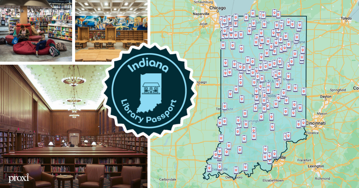
Literary Landscapes: The Indiana State Library Passport Map
Navigating the 160+ Indiana Libraries has never been easier.

Adding Value, Creating Impact: Why Traveling While Black Loves Proxi
Learn how Marlie and Anthony utilize Proxi to combine place and purpose

More than 10 million iOS and Android users worldwide have used TravelBoast since its release. It’s been the most popular mobile app in more than 30 countries.
Our users are very inventive! In 2022, they blew up TikTok with their fun distance map trend and educational Guess the Empire videos.

Over time, memories of even the most exciting trips start to fade. TravelBoast lets you record every detail of your journey, note the cities you visited, and add your best photos.
It’s lovely to reminisce about past journeys or share them with your friends.

Getting to grips with the app takes just 5–10 minutes. We’re always happy to answer questions and help you if you’re struggling with something.

With almost 100 different modes of transport to choose from, you’ll almost certainly be able to find the one you need.

Our app lets you import GPX tracks from almost any tracker. Record your route and send the track to TravelBoast to get a beautiful map.

Privacy Overview
All Mars Resources

Perseverance’s ‘Bunsen Peak’ Sample
NASA’s Perseverance Mars rover captured this image of a sample cored from a rock called “Bunsen Peak” on March 11,…

NASA’s Curiosity Rover Reaches Gediz Vallis Channel (360 View)
360-degree panorama provided by NASA’s Curiosity Mars rover. This view was captured at Gediz Vallis channel, a feature that formed…

Animation of Mars Helicopter Flight Test
This animation shows a simulation of the response of NASA’s Ingenuity Mars Helicopter to the system identification, or “Sys-ID,” process.…

Rover, Helicopter Locations in Jezero Crater
This map shows the locations of NASA’ Perseverance rover (white star) and Ingenuity Mars Helicopter (cyan star) on Dec. 19,…

Sol 4132: Right Navigation Camera, Cylindrical Projection
NASA’s Mars rover Curiosity took 31 images in Gale Crater using its mast-mounted Right Navigation Camera (Navcam) to create this…

Sol 4130: Right Navigation Camera, Cylindrical Projection
NASA's Mars rover Curiosity took 31 images in Gale Crater using its mast-mounted Right Navigation Camera (Navcam) to create this…

Sol 4128: Right Navigation Camera, Cylindrical Perspective
NASA's Mars rover Curiosity took 30 images in Gale Crater using its mast-mounted Right Navigation Camera (Navcam) to create this…

Sol 4128: Left Navigation Camera, Vertical Projection
NASA's Mars rover Curiosity took 30 images in Gale Crater using its mast-mounted Left Navigation Camera (Navcam) to create this…

Sol 4128: Left Navigation Camera, Cylindrical Perspective

Sol 4128: Left Navigation Camera, Cylindrical Projection

Sol 4128: Mast-Mounted Navigation Camera, Cylindrical Perspective
NASA's Mars rover Curiosity took 30 image pairs in Gale Crater using its mast-mounted Navigation Camera (Navcam) to create this…

Sol 4128: Right Navigation Camera, Cylindrical Projection

Sol 4125: Right Navigation Camera, Cylindrical Projection
NASA's Mars rover Curiosity took 52 images in Gale Crater using its mast-mounted Right Navigation Camera (Navcam) to create this…

Sol 4123: Right Navigation Camera, Cylindrical Projection
NASA's Mars rover Curiosity took 51 images in Gale Crater using its mast-mounted Right Navigation Camera (Navcam) to create this…

Sol 4118: Right Navigation Camera, Cylindrical Projection
NASA's Mars rover Curiosity took 49 images in Gale Crater using its mast-mounted Right Navigation Camera (Navcam) to create this…
IMAGES
VIDEO
COMMENTS
If you're too busy to create your first animated travel map right now, or you think your friends can wait being WOW-ed by your last amazing trip, join our community. We'll remind you later that your travel photos can still get the attention they deserve. Keep me posted. Create your animated travel map within minutes with PictraMap - a free ...
Create animated maps for video. Free animated map maker. We use cookies to improve our service. Learn more → ...
Animated travel infographics. Zero-config animated maps. Visualize your journey with beautiful animated maps. Perfect for adventurers, travelers, and explorers wanting to showcase their routes and destinations. Hey mate, this site is awesome! As a s/w product mgr myself, this is very well-done! I was googling for something exactly like this for ...
TravelAnimator - The best of the lot. TravelAnimator gets your job of creating fun animated travel maps pretty easily. It is a highly-rated app on the Play Store and App Store. It allows you to ...
Design, Create, Animate and Share Maps - All in one place! GEOlayers.app lets you create animated maps in a breeze! Unlock your imagination: effortlessly select colors, design harmonious basemaps, create outstanding labels, and more! Seamlessly animate with our item-based timeline - Say goodbye to fiddly keyframes and value graphs.
In this tutorial, we'll show you how to create a dynamic, interactive, and animated travel map for your travel and other videos using free tools. This power...
Free Animated Travel Map Maker to show your Road trips, Flight paths and Routes with interactive Custom pins. Download Now! ... and the bustling markets of Bangkok. The animated map feature makes my travels feel like a blockbuster movie. Absolutely in love. - Sophia L. Travel Animator is a game-changer! I used to spend hours editing my travel ...
One of the key features of Map My Travels is to customize the way you want to show waypoints on your travel map. That's why you can add markers to your map in multiple ways: Create your own using the custom marker builder. Customize the marker icon and border and fill colors. Upload your own marker icon and resize it to your needs.
Anyone can create animated maps. Create impactful, dynamic video maps and animations in one tool and never worry about post-production. Mapcreator allows you to share, embed and broadcast animations without a hassle. Embed your animated map to your website, social media or whenever you want to use it. Create an Animated Map Now! Book a free demo
Route Animation. With roadtripplaner, a versatile travel map generator, you have the ability to personalize your route animation. Customize the color of your route to match your preferences or branding. Choose from a variety of vehicle icons to represent your mode of transportation, making your map even more engaging. Create a visually stunning ...
Free online map maker. Make a custom map. Easy to create and customize. Professionally designed and formatted. Millions of photos, icons and illustrations. Easily download or share. Design stunning custom maps with ease. No art background or design software necessary. Use Canva's free online map maker and create your maps you can add to ...
Add your travel destinations on a map, select your transport modes, visualize and share your itinerary for free. My itinerary This is a free demo version of our mapping software. Create an account to save your current itinerary and get access to all our features. ...
Earth Studio works with the desktop version of Google Chrome. Sign in with your Google account to request access. Learn more. A web-based animation tool for Google Earth's satellite and 3D imagery.
Use Wanderlog to share your itinerary with tripmates, friends, and families and collaborate in real time, so everyone stays in the loop. Plan your road trip or vacation with the best itinerary and trip planner. Wanderlog travel planner allows you to create itineraries with friends, mark routes, and optimize maps — on web or mobile app.
Create a free travel blog with an interactive Google Map. TravelMap lets you map the route from your travel itinerary to show countries and places visited.
MapFling: easily share free maps with your own custom markers! MapFling is a free Web 2.0 AJAX online service which lets you: Free Maps Bring up a map of nearly any city or country in the world (a road map, aerial photogaphy, a satellite image, or a hybrid map), Mark Custom Points on Map with your own Annotation or Description
First, install SmartSHOW 3D on your computer. Click the button below and start your free trial. Download free. For Windows 11, 10, 8, 7. Step 2. Create Your Travel Project. Once you open the program, click New Project. Switch to the Effect tab and in the Motion section, pick the Travel Map animation effect.
Hi, I'm Chelsey, a co-founder of Proxi Interactive Maps. In this video, I'll introduce you to Proxi, the world's easiest-to-use map creation tool. Proxi is perfect for marketing teams, media companies, sales teams, economic developers, and destination marketers. I'll show you how Proxi can help you create event maps, maps of local businesses ...
Create without limits with a subscription to https://elements.envato.com/?utm_campaign=elements_social_eyt_E2cb0-7bpJg&utm_medium=social&utm_source=YouTube&u...
More than 10 million iOS and Android users worldwide have used TravelBoast since its release. It's been the most popular mobile app in more than 30 countries. Our users are very inventive! In 2022, they blew up TikTok with their fun distance map trend and educational Guess the Empire videos.
Free Online Travel Animation Video Maker. Elevate your travel storytelling with travel animation videos made on FlexClip's free online travel animation video maker, a game-changer in video production that saves you time and money. Be it captivating travel map animation, dynamic travel logo animation, or engaging travel video intro animation ...
This animation shows a simulation of the response of NASA's Ingenuity Mars Helicopter to the system identification, or "Sys-ID," process.… Rover, Helicopter Locations in Jezero Crater This map shows the locations of NASA' Perseverance rover (white star) and Ingenuity Mars Helicopter (cyan star) on Dec. 19,…